Mount Wilson (Colorado)
| Mount Wilson | |
|---|---|

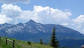
Mount Wilson is the peak in the far left background of this photo. (Wilson Peak is in the center foreground.)
|
|
| Highest point | |
| Elevation | 14,252 ft (4344 m) NAVD88 |
| Prominence | 4024 ft (1227 m) |
| Isolation | 33.0 mi (53.1 km) |
| Listing | |
| Coordinates | 37°50′21″N 107°59′29″W / 37.8391607°N 107.9914581°WCoordinates: 37°50′21″N 107°59′29″W / 37.8391607°N 107.9914581°W |
| Geography | |
|
|
|
| Location | High point of Dolores County, Colorado, United States |
| Parent range |
Highest summit of the San Miguel Mountains |
| Topo map |
USGS 7.5' topographic map Mount Wilson, Colorado |
| Climbing | |
| First ascent | September 13, 1874, by A. D. Wilson, Franklin Rhoda, and others (Hayden Survey party) |
| Easiest route | North Face (hike/snow climb/scramble) |
Mount Wilson is the highest summit of the San Miguel Mountains range of the Rocky Mountains of North America. The prominent 14,252-foot (4,344 m) fourteener is located in the Lizard Head Wilderness of San Juan National Forest, 10.6 miles (17.1 km) north by east (bearing 12°) of the Town of Rico in Dolores County, Colorado, United States. Mount Wilson should not to be confused with the lower Wilson Peak nearby.
The peak was named for A.D. Wilson, a topographer with the Hayden Survey. He was in the first ascent party, which climbed the peak on September 13, 1874, via the south ridge (a difficult route, not often climbed today).
Mount Wilson is ranked among the top ten hardest of the Colorado fourteeners to climb. The standard climbing route ascends the North Face from Navajo Basin. Some permanent snowfields exist high in the basin (sometimes termed "Navajo Glacier") and the climb usually involves snow travel, with ice axe and crampons recommended. Scrambling on rock then leads to the summit.
A popular, though long, outing for expert climbers is the mile-long ridge connecting Mount Wilson to El Diente Peak. The ridge is sharp and rocky, and requires difficult scrambling and often a small amount of rappelling.
...
Wikipedia

