Mount Washington (Oregon)
| Mount Washington | |
|---|---|

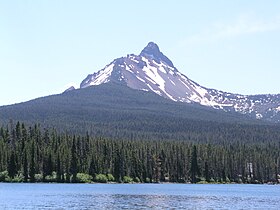
Mount Washington from Big Lake
|
|
| Highest point | |
| Elevation | 7,798 ft (2,377 m) NAVD 88 |
| Prominence | 2,554 ft (778 m) |
| Coordinates | 44°19′56″N 121°50′19″W / 44.3321254°N 121.8385292°WCoordinates: 44°19′56″N 121°50′19″W / 44.3321254°N 121.8385292°W |
| Geography | |
| Location | Deschutes / Linn counties, Oregon, U.S. |
| Parent range | Cascade Range |
| Topo map | USGS Mount Washington |
| Geology | |
| Age of rock | |
| Mountain type | Shield volcano |
| Volcanic arc | Cascade Volcanic Arc |
| Last eruption | About 670 AD |
| Climbing | |
| First ascent | 1923 by E. McNeal and party |
Mount Washington is a deeply eroded shield volcano in the Cascade Range of Oregon. The mountain dates to the Late . However, it does have a line of basaltic andesite spatter cones on its northeast flank which is approximately 1,330 years old (dating from the Holocene) according to carbon dating. The main peak is a volcanic plug that was heavily eroded by glaciers in the last ice age.
Mount Washington was first ascended on August 26, 1923 by Ervin McNeal, Phil Philbrook, Armin Furrer, Wilbur Watkins, Leo Harryman, and Ronald Sellars.
...
Wikipedia
