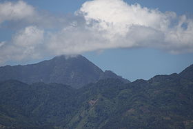
Mount Talinis
| Mount Talinis | |
|---|---|
| Cuernos de Negros | |
 |
|
| Highest point | |
| Elevation | 1,903 m (6,243 ft) |
| Listing | Potentially active volcano |
| Coordinates | 9°15′0″N 123°10′0″E / 9.25000°N 123.16667°ECoordinates: 9°15′0″N 123°10′0″E / 9.25000°N 123.16667°E |
| Geography | |
| Location | Negros |
| Country | Philippines |
| Region | Negros Island Region |
| Province | Negros Oriental |
| Geology | |
| Age of rock | Late Miocene |
| Mountain type | Complex volcano |
| Volcanic arc/belt | Negros Volcanic Belt |
| Last eruption | Unknown |
Mount Talinis, also known as the Cuernos de Negros (Horns of Negros), is a complex volcano in the Philippine province of Negros Oriental. At about 1,903 metres (6,243 ft) above sea level, it is the second highest mountain on Negros Island after Mount Kanlaon. The volcano is located 9 km (5.6 mi) southwest of the municipality of Valencia; and 20 km (12 mi) from Dumaguete City, the capital of the province.
Cuernos de Negros is classified by the Philippine Institute of Volcanology and Seismology as a potentially active volcano forming part of the Negros Volcanic Belt. Andesite and basalt are the most abundant rocks found on the mountain. With a base diameter of 36 kilometres (22 mi), the volcanic complex is composed of several volcanic cones and peaks, the most prominent of which are Talinis, Cuernos de Negros, Guinsayawan, Yagumyum Peak and Guintabon Dome. The mountain range is very fumarolic with several solfataras and steam vents located on its slope that are harnessed to generate electricity. The Southern Negros Geothermal Production Field in Palinpinon generates 192.5 MW.
Cuernos de Negros volcanic complex is popular with visitors for the natural beauty of the forest and many volcanic lakes surrounded by mountains.
Within the volcano complex is Balinsasayao Twin Lakes Natural Park, a national park established on November 21, 2000 by Proclamation No. 414. It is a most visited park of which the twin crater lakes of Balinsasayao and Danao are located, separated only by a narrow mountain ridge. Lake Kabalin-an, a smaller lake, is located before the two lakes. All three lakes are located within the Guintabon Caldera.
...
Wikipedia

