Mount Sterling, Kentucky
| Mount Sterling, Kentucky | |
|---|---|
| City | |

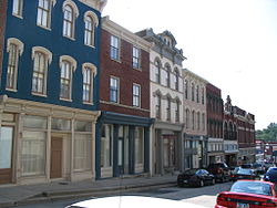
Downtown Mt. Sterling
|
|
| Motto: "Ringing with Unity and Pride" | |
 Location of Mount Sterling, Kentucky |
|
| Coordinates: 38°3′24″N 83°56′40″W / 38.05667°N 83.94444°WCoordinates: 38°3′24″N 83°56′40″W / 38.05667°N 83.94444°W | |
| Country | United States |
| State | Kentucky |
| County | Montgomery |
| Established | 1792 |
| Incorporated | 1852 |
| Area | |
| • Total | 3.4 sq mi (8.9 km2) |
| • Land | 3.4 sq mi (8.9 km2) |
| • Water | 0.0 sq mi (0.0 km2) |
| Elevation | 974 ft (297 m) |
| Population (2010) | |
| • Total | 6,895 |
| • Density | 1,708.9/sq mi (659.8/km2) |
| Time zone | Eastern (EST) (UTC-5) |
| • Summer (DST) | EDT (UTC-4) |
| ZIP code | 40353 |
| Area code(s) | 859 |
| FIPS code | 21-54084 |
| GNIS feature ID | 0498865 |
Mount Sterling – often written as Mt. Sterling – is a home rule-class city in Montgomery County, Kentucky, in the United States. The population was 6,895 at the 2010 U.S. census. It is the county seat of Montgomery County and the principal city of the Mount Sterling micropolitan area.
Mount Sterling is named for an ancient burial mound called Little Mountain, and for the town of Stirling in Scotland. It was named by the first developer of the area, Hugh Forbes. The Kentucky Assembly passed an act in 1792 establishing the town as Mt. Sterling, a misspelling which was retained.
The area was originally part of the thick wilderness of central Kentucky. Explorers, hunters, and surveyors traveling along a trail called Old Harper's Trace noted a 125-foot-high tree-covered mound which they called The Little Mountain. Later excavations showed it to be a burial site. The site of the mound is now the intersection of Queen and Locust streets in Mt. Sterling.
The first cabin in the area was built in 1779. The first permanent settlement was established around 1790, when Forbes began to sell lots and laid out a road, now Locust Street. In 1796 the town was established as the county seat of newly created Montgomery County. At that time the town consisted of 33 town lots, four retail stores, and three taverns. A courthouse was built, the first of seven to be housed in Mt. Sterling. A jail and a town pump were also installed. A large brick market house where farm produce was bought and sold confirmed the town as the commercial center of the surrounding area. Baptist, Presbyterian and Methodist churches were established during the town's first decade.
During the Civil War the town was occupied alternately by Union and Confederate troops on multiple occasions. The Battle of Mt. Sterling in June 1864, which ended in a Confederate defeat, was the last of the fighting in Montgomery County.
...
Wikipedia
