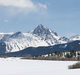
Mount Sneffels
| Mount Sneffels | |
|---|---|

View of Mount Sneffels from the north
|
|
| Highest point | |
| Elevation | 14,150 ft (4315.4 m) NAVD88 |
| Prominence | 3050 ft (930 m) |
| Isolation | 15.71 mi (25.3 km) |
| Listing | |
| Coordinates | 38°00′14″N 107°47′32″W / 38.0038357°N 107.7923478°WCoordinates: 38°00′14″N 107°47′32″W / 38.0038357°N 107.7923478°W |
| Geography | |
|
|
|
| Location | High point of Ouray County, Colorado, United States |
| Parent range | San Juan Mountains, Highest summit of the Sneffels Range |
| Topo map |
USGS 7.5' topographic map Mount Sneffels, Colorado |
Mount Sneffels is the highest summit of the Sneffels Range in the Rocky Mountains of North America. The prominent 14,158-foot (4315.4 m) fourteener is located in the Mount Sneffels Wilderness of Uncompahgre National Forest, 6.7 miles (10.8 km) west by south (bearing 256°) of the City of Ouray in Ouray County, Colorado, United States. The summit of Mount Sneffels is the highest point in Ouray County.
Mount Sneffels is notable for its great vertical relief, as it rises 7,200 feet above the town of Ridgway, Colorado 6 miles to the northeast.
The primary route to the summit follows a creek bed up from Yankee Boy Basin. A secondary route follows a ridge line to the summit from the saddle of Blue Lakes Pass.
Mount Sneffels was named after the volcano Snæfell, which is located on the tip of the Snæfellsnes peninsula in Iceland. That mountain and its glacier, Snæfellsjökull, which caps the crater like a convex lens, were featured in the Jules Verne novel A Journey to the Center of the Earth. An area on the western flank of Mount Sneffels gives the appearance of volcanic crater.
...
Wikipedia

