Mount Pleasant (New Zealand)
| Mount Pleasant | |
|---|---|
| Tauhinu Korokio | |

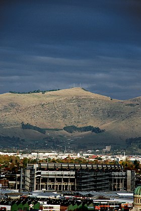
A view of Mount Pleasant, with AMI Stadium in the foreground (From Hotel Grand Chancellor, demolished after the 2011 Christchurch earthquake)
|
|
| Highest point | |
| Elevation | 499 m (1,637 ft) |
| Coordinates | 43°35′20″S 172°43′38″E / 43.589°S 172.72728°ECoordinates: 43°35′20″S 172°43′38″E / 43.589°S 172.72728°E |
| Geography | |
|
Location of Mount Pleasant in Christchurch, New Zealand
|
|
| Location | Christchurch |
| Parent range | Port Hills |
| Geology | |
| Mountain type | Basalt volcanic rock |
Mount Pleasant (Māori: Tauhinu Korokio or Tauhinukorokio) is the highest elevation in the eastern Port Hills in Christchurch, New Zealand. It once held a Māori pā, but there was little left of it when European settlers first arrived in the 1840s. The hill was first used as a sheep run, and became the base trig station for the survey of Canterbury. It was also used as a signal station to make residents aware of ships coming into Lyttelton Harbour. During World War II, an extensive heavy anti-aircraft artillery (HAA) battery was built near the summit, and the foundations of those buildings still exist.
Mount Pleasant is located in the Port Hills and is 499 metres (1,637 ft) high. On its northern slope is the Christchurch suburb of Mount Pleasant, and on its southern side is Lyttelton Harbour.
The Māori name of the hill is Tauhinu Korokio, which refers to two native plants. The first, Tauhinu, is a cottonwood (Ozothamnus leptophyllus) of the genus Ozothamnus. Korokio is a densely branched Cotoneaster (Corokia cotoneaster). The New Zealand Geographic Board officially changed the name to Tauhinukorokio/Mount Pleasant in September 1948, which was gazetted in The New Zealand Gazette 1949 on page 858.
The European name was given by crew of the HMS Pegasus when the coastal survey of Canterbury was undertaken in 1809.Joseph Thomas, the chief surveyor of the Canterbury Association, climbed the mountain in late 1848 immediately after arriving in Canterbury, and although being aware of the European name, renamed the hill Mount Cavendish in honour of Lord Richard Cavendish, a member of the management committee of the Canterbury Association. The name did not come into common use and was eventually transferred to an adjacent hill.
...
Wikipedia

