Mosterøy
| Mosterøy herad | |
|---|---|
| Former Municipality | |

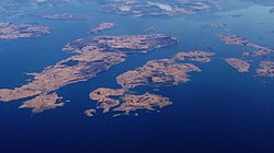
Mosterøy municipality included the islands on the right half of the picture
|
|
| Location in Rogaland county | |
| Coordinates: 59°05′07″N 05°38′11″E / 59.08528°N 5.63639°ECoordinates: 59°05′07″N 05°38′11″E / 59.08528°N 5.63639°E | |
| Country | Norway |
| Region | Western Norway |
| County | Rogaland |
| District | Ryfylke |
| Municipality ID | NO-1143 |
| Adm. Center | Askje |
| Area | |
| • Total | 23 km2 (9 sq mi) |
| Time zone | CET (UTC+01:00) |
| • Summer (DST) | CEST (UTC+02:00) |
| Created from | Rennesøy in 1884 |
| Merged into | Rennesøy in 1965 |
Mosterøy is a former municipality in Rogaland county, Norway. The administrative centre was the village of Askje where the Askje Church is located. The 23-square-kilometre (8.9 sq mi) municipality existed from 1884 until 1965. The island municipality included the islands of Mosterøy, Klosterøy, Fjøløy, Sokn, Bru, and the western half of Åmøy. Today, Mosterøy is part of the municipality of Rennesøy.
The Utstein Abbey, the best-preserved medieval monastery in Norway, is located on the island of Klosterøy. It was one of the most notable historic sites in the municipality.
The municipality of Mosterøy was established on 1 July 1884 when it was split off from the large island municipality of Rennesøy. Initially, the new municipality had a population of 1,309. On 1 January 1923, the westernmost group of outlying islands of Kvitsøy were separated from Mosterøy to form a separate municipality Kvitsøy. The split left Mosterøy with 745 inhabitants. On 1 January 1965, many municipal mergers took place in Norway due to the recommendations of the Schei Committee. On that date, Mosterøy was merged back into the municipality of Rennesøy. Prior to the merger, Mosterøy had a population of 817.
...
Wikipedia

