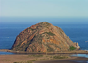
Morro Rock
| Morro Rock | |
|---|---|

Morro Rock looking west.
|
|
| Highest point | |
| Elevation | 581 ft (177 m) NAVD 88 |
| Coordinates | 35°22′10″N 120°52′03″W / 35.369430653°N 120.867550139°WCoordinates: 35°22′10″N 120°52′03″W / 35.369430653°N 120.867550139°W |
| Geography | |
|
|
|
| Parent range | Santa Lucia Range |
| Topo map | USGS Morro Bay South |
| Geology | |
| Age of rock | c. 23 million years |
| Mountain type | Volcanic plug |
| Volcanic arc/belt | Nine Sisters |
| Designated | January 1, 1968 |
| Reference no. | 821 |
Morro Rock is a 581-foot (177 m)volcanic plug located just offshore from Morro Bay, California, at the entrance to Morro Bay Harbor. A causeway connects it with the shore, effectively making it a tied island. The area surrounding the base of Morro Rock can be visited. The rock is protected as the Morro Rock State Preserve. Climbing on the rock or disturbing the bird life is forbidden by law.
Geologically, Morro Rock, located in San Luis Obispo County, in the town of Morro Bay, California, is one of 13 volcanic, intrusive units that form volcanic plugs (remnant volcanic necks of volcanoes), lava domes, and sheetlike intrusions from Morro Rock southeast 29 km or 18 mi to Islay Hill. The plugs form the distinctive peaks along U.S. Highway 101 just south of San Luis Obispo and south of State Highway 1 from San Luis Obispo to Morro Bay. The rock is composed of dacite, a felsic extrusive rock, intermediate in composition between andesite and rhyolite, and is a member of the igneous family. Its lithology and composition is a groundmass of plagioclase with amphibole (hornblende), biotite, pyroxene (augite), quartz, and glass; phenocrysts of plagioclase, amphibole and often quartz. Its silica (SiO2) content can range from 63%-69%. The dacite volcanic plugs, lava domes, intrusive sheets, and felsitic rhyolite-dacite between Morro Rock and Islay Hill are part of the Oligocene (27-23 Ma) Mono Rock-Islay Hill Complex. The complex lies east of the San Gregorio-San Simeon-Hosgri fault (SG-SS-H fault). This complex is one of three probable sources of the volcanic clasts within the sandstone and conglomerate of the Miguelito and Edna members of the Pismo Formation in the Point Sur area 145–160 km (90-100 mi) to the north and west of the SG-SS-H fault. Based on paleomagnetic signatures, the 27-23 Ma Morro Rock-Islay Hill Complex was rotated 40'-50',perhaps during late Miocene or early Pliocene time.
The rock was quarried on and off from 1889 to 1969, and provided material for the breakwater of Morro Bay and Port San Luis Harbor. In 1966, a state law was adopted that transferred title to the State of California. In February 1968, the San Luis Obispo County Historical Society and the City of Morro Bay succeeded in having Morro Rock declared California Historical Landmark number 821.
...
Wikipedia


