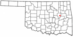
Morris, Oklahoma
| Morris, Oklahoma | |
|---|---|
| City | |
| Motto: The Little City With a Big Welcome | |
 Location of Morris, Oklahoma |
|
| Coordinates: 35°36′36″N 95°51′40″W / 35.61000°N 95.86111°WCoordinates: 35°36′36″N 95°51′40″W / 35.61000°N 95.86111°W | |
| Country | United States |
| State | Oklahoma |
| County | Okmulgee |
| Area | |
| • Total | 1.2 sq mi (3.0 km2) |
| • Land | 1.1 sq mi (2.9 km2) |
| • Water | 0.1 sq mi (0.1 km2) |
| Elevation | 722 ft (220 m) |
| Population (2010) | |
| • Total | 1,479 |
| • Density | 1,344.5/sq mi (510.0/km2) |
| Time zone | Central (CST) (UTC-6) |
| • Summer (DST) | CDT (UTC-5) |
| ZIP code | 74445 |
| Area code(s) | 539/918 |
| FIPS code | 40-49400 |
| GNIS feature ID | 1095519 |
Morris is a city in Okmulgee County, Oklahoma, United States. The population was 1,494 at the 2010 census, an increase of 14.3 percent from 1,294 at the 2000 census.
The community began as a cattle stop on the Ozark and Cherokee Central Railway (later the St. Louis and San Francisco Railway) which ran between Muskogee and Okmulgee. The post office was established here on January 4, 1904. The origin of the town name is not known.
The townsite was platted in 1904 by L. R. Kershaw, who was an attorney and was also an Immigration Agent for the Frisco (St. Louis–San Francisco Railway) Railroad. He named the town after H. E. Morris, a Frisco Railroad executive. Many of the street names in Morris are named after towns which were familiar to Kershaw from his home state of Illinois. Kershaw was also the founder of two of the earliest banks in Morris, Indian Territory: The Farmer's State Bank of Morris in 1905 and the First National Bank of Morris in 1907.
The Morris News, a newspaper founded in 1910 has continued publication into the 20th Century.
A tornado struck Morris on April 26, 1984. It killed nine people and destroyed the entire business section, as well as about one half of the housing.
Morris is located at 35°36′36″N 95°51′40″W / 35.61000°N 95.86111°W (35.610041, -95.861038). It is 8 miles (13 km) east of Okmulgee, at the intersection of U. S. Highway 62 and State Highway 52.
According to the United States Census Bureau, the city has a total area of 1.2 square miles (3.1 km2), of which, 1.1 square miles (2.8 km2) of it is land and 0.1 square miles (0.26 km2) of it (5.17%) is water.
...
Wikipedia
