Morganton, North Carolina
| Morganton, North Carolina | |
|---|---|
| City | |

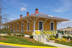
Historic train station in Morganton
|
|
 |
|
| Coordinates: 35°44′33″N 81°41′32″W / 35.74250°N 81.69222°WCoordinates: 35°44′33″N 81°41′32″W / 35.74250°N 81.69222°W | |
| Country | United States |
| State | North Carolina |
| County | Burke |
| Founded | 1777 |
| Incorporated | 1784 |
| Government | |
| • Mayor | Ronnie Thompson |
| Area | |
| • Total | 19.2 sq mi (49.6 km2) |
| • Land | 19.2 sq mi (49.6 km2) |
| • Water | 10.20 sq mi (26.42 km2) |
| Elevation | 1,161 ft (354 m) |
| Population (2010) | |
| • Total | 16,918 |
| • Density | 883/sq mi (341.1/km2) |
| Time zone | Eastern (UTC-5) |
| • Summer (DST) | Eastern (UTC-4) |
| ZIP codes | 28655, 28680 |
| Area code(s) | 828 |
| FIPS code | 37-44400 |
| GNIS feature ID | 0990244 |
| Website | www |
Morganton is a city in Burke County, North Carolina, United States. The population was 16,918 at the 2010 census. Morganton is the county seat.
Morganton is one of the principal cities in the Hickory-Lenoir-Morganton, NC Metropolitan Statistical Area. A site five miles north of here has been identified as the Mississippian culture chiefdom of Joara, occupied from 1400AD to 1600AD. This was also the site of Fort San Juan, built in 1567 by a Spanish expedition as the first European settlement in the interior of North America, 40 years before the English settlement of Jamestown, Virginia.
The oldest-known European inland (non-coastal) settlement in the United States of Fort San Juan has been identified at Joara, a former Mississippian culture chiefdom located about five miles north of present-day Morganton. In 1567 a Spanish expedition built the fort there, while seeking to establish an interior route to Mexican silver mines. (They did not have an accurate grasp of the geography.) This was more than 40 years before the English settled Jamestown, Virginia, their first permanent settlement in North America.
The Spanish left a 31-man garrison that occupied the fort for 18 months before being overcome in a Mississippian attack. Five other Spanish forts in the larger interior region were also destroyed about that time. Only one soldier survived. The fort and Indian settlement have been under professional excavation since the early 21st century, with findings published since 2004. Europeans associated with the British colonies did not try to settle this far west for nearly 200 years, organizing Burke County in 1777.
Today Joara is identified as a significant archaeological and historic site near the Watersee River in the Upper Catawba Valley. Construction of its mounds is believed to have been started by the people of the Mississippian culture by AD 1000, and they occupied the site continuously from 1400AD to 1600AD. Based on additional archeological excavations at the "Berry Site" that revealed the remains of a defensive moat constructed in European style, researchers in 2013 concluded that this was the site of Fort San Juan and Joara. Earlier evidence found in the area included "military artifacts and burned remains of Spanish-built huts."
...
Wikipedia
