Moreton Island, Queensland
| Native name: Moorgumpin | |
|---|---|

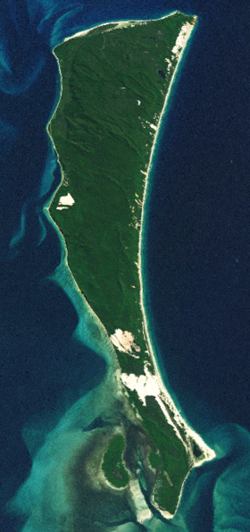
Moreton Island satellite image
|
|
|
Location of Moreton Island in Queensland
|
|
| Geography | |
| Location | Coral Sea; Moreton Bay |
| Coordinates | 27°10′S 153°24′E / 27.167°S 153.400°ECoordinates: 27°10′S 153°24′E / 27.167°S 153.400°E |
| Area | 186 km2 (72 sq mi) |
| Length | 44 km (27.3 mi) |
| Width | 13 km (8.1 mi) |
| Highest elevation | 280 m (920 ft) |
| Highest point | Mount Tempest |
| Administration | |
|
Australia
|
|
| State | Queensland |
| Region | South East Queensland |
| Local government area | City of Brisbane |
| Demographics | |
| Population | 298 (2011 census) |
Moreton Island is an island on the eastern side of Moreton Bay on the coast of South East Queensland, Australia. The Coral Sea lies on the east coast of the island. Moreton Island lies 58 kilometres (36 mi) northeast of the Queensland capital, Brisbane. 95% of the island is contained within a national park and a popular destination for day trippers, four wheel driving, camping, recreational angling and whale watching and just a 75-minute ferry ride from Brisbane. It is the third largest sand island in the world. Together with Fraser Island, Moreton Island forms the largest sand structure in the world.
The island is within the City of Brisbane and is gazetted into four localities, the small townships of Bulwer, Cowan Cowan and Kooringal with the bulk of the island being the locality of Moreton Island. The Tangalooma tourist resort is within the locality of Moreton Island. All residential areas are located on the western coast of the island facing Moreton Bay.
The island was named by Matthew Flinders. At least five lighthouses have been built on the island. A small number of residents live in four small settlements. Tangalooma was the site of a whaling station. Access to the island is by vehicular barge or passenger ferry services. Moreton Island is a popular destination for camping and fishing.
It is one of the wettest parts of the City of Brisbane with precipitation spread evenly throughout the year compared to other parts of South East Queensland. Cape Moreton receives an annual average rainfall of 1,567 millimetres (61.7 in).
The island covers an area of approximately 186 square kilometres (72 sq mi), and extends for 37 kilometres (23 mi) from north to south and is 13 kilometres (8.1 mi) at its widest point.Cape Moreton, at the north eastern tip of the island, is the only rock outcrop on the island. It was named Cape Morton by Captain James Cook in May 1770, and was at that time assumed to be part of the mainland. The current spelling came about because of a clerical error later.
...
Wikipedia

