Moorea Airport
|
Moorea Airport Aéroport de Moorea Moorea Temae Airport |
|||||||||||
|---|---|---|---|---|---|---|---|---|---|---|---|

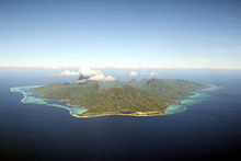
View on approach to Moorea Airport
|
|||||||||||
| Summary | |||||||||||
| Airport type | Public | ||||||||||
| Operator | SETIL Aéroports | ||||||||||
| Serves | Moorea, French Polynesia | ||||||||||
| Elevation AMSL | 16 ft / 5 m | ||||||||||
| Coordinates | 17°29′22″S 149°45′44″W / 17.48944°S 149.76222°W | ||||||||||
| Map | |||||||||||
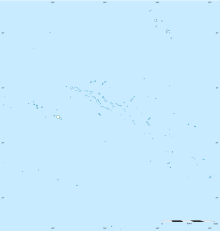
| Location of airport in French Polynesia | |||||||||||
| Runways | |||||||||||
|
|||||||||||
Moorea Airport (French: Aéroport de Moorea) (IATA: MOZ, ICAO: NTTM) is an airport serving the island of Moorea in French Polynesia. It is also known as Temae Airport or Moorea Temae Airport for its location near the village of Temae in northeastern Moorea. The airport is located 7.5 km (4.0 NM) northeast of Afareitu, the island's main village. It is also 15 km (8.1 NM) west of the island of Tahiti. The airport opened on October 6, 1967.
The airport resides at an elevation of 16 feet (5 m) above mean sea level. It has one runway designated 12/30 with an asphalt surface measuring 1,237 by 30 metres (4,058 ft × 98 ft).
The Moorea Tour Bus comes to the airport to pick up or drop off people. The bus is yellow and green.
Annual statistics for Moorea Airport:
...
Wikipedia

