Montgrí Massif
| Montgrí | |
|---|---|

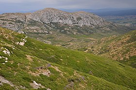
Landscape in the Montgrí Massif, with the Valley of Santa Caterina and the rocky Puig Rodó.
|
|
| Highest point | |
| Elevation | 310.8 m (1,020 ft) |
| Coordinates | 42°03′42″N 3°07′15″E / 42.06167°N 3.12083°ECoordinates: 42°03′42″N 3°07′15″E / 42.06167°N 3.12083°E |
| Geography | |
|
|
|
| Parent range | Catalan Coastal Range |
| Geology | |
| Mountain type | Calcareous |
| Climbing | |
| First ascent | Unknown |
| Easiest route | From Torroella de Montgrí |
The Montgrí (Catalan pronunciation: [muŋˈɡɾi]) is a small mountain range in Catalonia, on the north bank of the Ter river. It is part of the Catalan Coastal Range and its highest point is 311 m.
The Montgrí Massif stretches from east to west north of the town of Torroella de Montgrí, sheltering it from the Tramontana northern wind. Local people call it simply "el Montgrí".
This long mountain formation looks like a sleeping bishop seen from afar. The Montgrí Massif is topped by an ancient fortress in the middle, the Montgrí Castle. Local people say the castle is the ring on the sleeping bishop's hand.
It is a largely denuded karstic mountain, beaten by the persistent winds that blow in the region. It has some dunes at its feet, on its northern side, which formed by windblown sand coming from the shores of distant Roses. These dunes were fixed about a century ago by and lie now covered under low forest.
The Medes Islands further east, beyond the town of l'Estartit, are a geological prolongation of this massif.
The vegetation on this massif consists mostly of low mediterranean scrub among rocks. There are some clumps of Mediterranean fan palm (Chamaerops humilis), being one of the northernmost locations where this small palm grows wild. The lower edges of the mountain have some mediterranean forest, made up mainly of pine (Pinus halepensis), as well as some cork oak (Quercus suber) and oak (Quercus sp.).
...
Wikipedia

