Montgomery County Airpark
| Montgomery County Airpark | |||||||||||
|---|---|---|---|---|---|---|---|---|---|---|---|

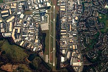
The Montgomery County Airpark in 2006
|
|||||||||||
| Summary | |||||||||||
| Airport type | Public | ||||||||||
| Owner | Montgomery County Revenue Authority | ||||||||||
| Location | Gaithersburg, Maryland, U.S. | ||||||||||
| Elevation AMSL | 539 ft / 164.3 m | ||||||||||
| Coordinates | 39°10′06″N 77°09′57.6″W / 39.16833°N 77.166000°WCoordinates: 39°10′06″N 77°09′57.6″W / 39.16833°N 77.166000°W | ||||||||||
| Map | |||||||||||
| Location of airport in Maryland / United States | |||||||||||
| Runways | |||||||||||
|
|||||||||||
Montgomery County Airpark (IATA: GAI, ICAO: KGAI, FAA LID: GAI) is a U.S. public airport located three miles (5 km) northeast of the city of Gaithersburg, in Montgomery County, Maryland.
The airport was built by developer William E. Richardson in 1960. Richardson deeded title to the land to Montgomery County, which leased the land back to Richardson to operate the airport. Richardson planned to operate charter flights and an air taxi to National Airport, Baltimore's Friendship Airport, and the soon-to-be-opened Dulles Airport. The airport was dedicated on October 22, 1960. After having a simple hangar during its first four years of operation, a terminal building was built in 1964.
On July 20, 2001, one of the hijackers in the future September 11 attacks, Hani Hanjour, flew to the Montgomery County Airpark from Fairfield, New Jersey on a practice flight with fellow hijacker Nawaf Alhazmi.
Montgomery County Airpark covers 125 acres (51 ha) and has one runway.
...
Wikipedia


