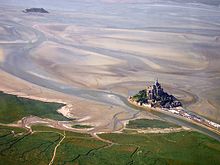
Mont Saint-Michel Bay
 |
|
| UNESCO World Heritage Site | |
|---|---|
| Location | France |
| Coordinates | 48°38′05″N 1°30′38″W / 48.6347°N 1.5106°W |
| Criteria | Cultural: (i), (iii), (vi) |
| Reference | 80-001 |
| Inscription | 1979 (3rd Session) |
|
[]
|
|
The Mont Saint-Michel Bay (French: Baie du mont Saint-Michel, Breton: Bae Menez-Mikael) is located between Brittany (to the south west) and the Normandy peninsula of Cotentin (to the south and east). The bay is part of the club of the world's most beautiful bays () and is listed as a UNESCO world heritage site. Due to the significant tidal movements in this region (over 10 meters) a large part of the bay is uncovered at low tide. There are two granitic islands in the bay: Tombelaine and the Mont Saint-Michel. Many birds and harbor seal live in this area.
Mont Saint-Michel Bay is about 500 km2 (190 sq mi) in size.
The following towns and villages surround the bay, from north to south:
Three small rivers end in the bay (and cross it at low tide): the Couesnon, now blocked to the west of Mont Saint-Michel by a causeway, the Sée and the Sélune. The very low slope of the bay and the very large tides formed a mascaret in those rivers that can travel upstream for many kilometers.
Three larger rivers end in the bay: the Sélune, the Sée and mainly the Couesnon that, accordingly to some local folk stories, was originally the boundary between Normandy and Brittany but then moved to the West of the Mont placing it in Normandy. In reality the boundary is not at the river location but 4 kilometres (2.5 mi) further to the west, at the foot of Mont Saint-Broladre.
...
Wikipedia

