Mohave Valley, Arizona
| Mohave Valley | |
|---|---|
| Census-designated place | |
 |
|
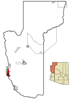
 Location in Mohave County and the state of Arizona |
|
| Location in the United States | |
| Coordinates: 34°57′25″N 114°35′5″W / 34.95694°N 114.58472°WCoordinates: 34°57′25″N 114°35′5″W / 34.95694°N 114.58472°W | |
| Country | United States |
| State | Arizona |
| County | Mohave |
| Area | |
| • Total | 45.3 sq mi (117.3 km2) |
| • Land | 45.3 sq mi (117.2 km2) |
| • Water | 0.2 sq mi (0.4 km2) |
| Elevation | 523 ft (159 m) |
| Population (2000) | |
| • Total | 13,694 |
| • Density | 302.6/sq mi (116.8/km2) |
| Time zone | MST (UTC-7) |
| ZIP codes | 86440, 86446 |
| Area code(s) | 928 |
| FIPS code | 04-47400 |
| GNIS feature ID | 1866989 |
Mohave Valley ('Amat' 'Analy Uuhwely in Mojave) is a census-designated place (CDP) in Mohave County, Arizona, United States. The population was 13,694 at the 2000 census. It is geographically connected to Needles, California, Fort Mohave, Arizona, and Bullhead City, Arizona.
The first recorded European to come through Mohave Valley was Melchor Díaz. He documented his travels in northwestern Mohave County in 1540. He recounts meeting a large population of natives who referred to themselves as the Pipa Aha Macav, meaning "People by the River". From "Aha Macav" came the shortened name "Mojave" (also spelled "Mohave"). While Mohave Valley and Mohave County use the modern English spelling, the tribe retains the traditional Spanish spelling "Mojave". Both are correct, and both are pronounced "Moh-hah-vee".
Mohave Valley is located at 34°57′25″N 114°35′5″W / 34.95694°N 114.58472°W (34.956929, -114.584613).
According to the United States Census Bureau, the CDP has a total area of 45.4 square miles (118 km2), of which, 45.3 square miles (117 km2) of it is land and 0.2 square miles (0.52 km2) of it (0.35%) is water.
As of the census of 2000, there were 13,694 people, 5,217 households, and 3,850 families residing in the CDP. The population density was 302.6 people per square mile (116.8/km²). There were 6,672 housing units at an average density of 147.4/sq mi (56.9/km²). The racial makeup of the CDP was 90.79% White, 0.45% Black or African American, 2.34% Native American, 0.94% Asian, 0.12% Pacific Islander, 3.26% from other races, and 2.10% from two or more races. 11.98% of the population were Hispanic or Latino of any race.
...
Wikipedia

