Mocho-Choshuenco
| Mocho-Choshuenco | |
|---|---|

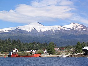
In the left; the Mocho cone and in the right the eroded Choshuenco. Puerto Fui at Pirihueico Lake in the foreground.
|
|
| Highest point | |
| Elevation | 2415 m (Choshuenco) 2422 m (Mocho) |
| Listing | Ultra |
| Coordinates | 39°54′35″S 72°2′15″W / 39.90972°S 72.03750°WCoordinates: 39°54′35″S 72°2′15″W / 39.90972°S 72.03750°W (Choshuenco) |
| Naming | |
| Pronunciation | Spanish: [ˈmotʃo tʃosˈweŋko] |
| Geography | |
| Location | Panguipulli, Futrono and Los Lagos, Chile |
| Parent range | Andes |
| Geology | |
| Mountain type | Stratovolcano |
| Volcanic arc/belt | South Volcanic Zone |
| Last eruption | 1937 |
| Climbing | |
| First ascent | 1934 Dr. Rudolf Haege, Kaerner and Steenbloock (Choshuenco) |
| Easiest route | Choshuenco (nearest village with provisions) – Enco – Río Blanco – Tumba del Buey – Mochos peak – Choshuencos peak (in that order) |
Mocho-Choshuenco (Pronounced: /ˈmɒtʃoʊ tʃɒsˈwɛnkoʊ/ MO-choh CHOS-wen-KOH) is a glacier covered compound stratovolcano in the Andes of Los Ríos Region, Chile. It is made of the twin volcanoes Choshuenco in the northwest and the Mocho in the southeast. The highest parts of the volcano are part of the Mocho-Choshuenco National Reserve while the eastern slopes are partly inside the Huilo-Huilo Natural Reserve.
Choshuenco, located on the northwest rim of the 4 km wide caldera, is of late glacial age. It has a heavily eroded crater and is currently dormant. Mocho is an andesitic-dacitic volcano placed above the caldera. Some parasitic craters and cinder cones are located on the southwest and northeast flanks of the stratovolcano. Mocho has its earliest certainly recorded eruption in 1759, older eruptions reported are uncertain due to the usage of different names and inexact maps.
...
Wikipedia
