Mobile Regional Airport
|
Mobile Regional Airport Coast Guard Aviation Training Center Mobile (former Bates Army Airfield) |
|||||||||||||||||||
|---|---|---|---|---|---|---|---|---|---|---|---|---|---|---|---|---|---|---|---|
 |
|||||||||||||||||||

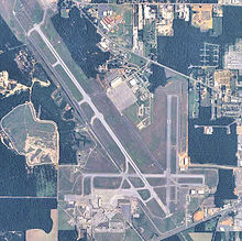
USGS 2006 orthophoto
|
|||||||||||||||||||
| Summary | |||||||||||||||||||
| Airport type | Public / Military | ||||||||||||||||||
| Owner/Operator | Mobile Airport Authority | ||||||||||||||||||
| Serves | Mobile, Alabama | ||||||||||||||||||
| Location | Mobile County | ||||||||||||||||||
| Elevation AMSL | 219 ft / 67 m | ||||||||||||||||||
| Coordinates | 30°41′29″N 088°14′34″W / 30.69139°N 88.24278°WCoordinates: 30°41′29″N 088°14′34″W / 30.69139°N 88.24278°W | ||||||||||||||||||
| Website | www.mobairport.com | ||||||||||||||||||
| Map | |||||||||||||||||||
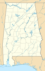
| Location in Alabama | |||||||||||||||||||
| Runways | |||||||||||||||||||
|
|||||||||||||||||||
| Helipads | |||||||||||||||||||
|
|||||||||||||||||||
| Statistics (2010) | |||||||||||||||||||
|
|||||||||||||||||||
|
Source: Federal Aviation Administration
|
|||||||||||||||||||
| Passengers/Enplanements: | 277,232 |
|---|---|
| Aircraft operations (2011): | 102,427 |
| Based aircraft: | 78 |
Mobile Regional Airport (IATA: MOB, ICAO: KMOB, FAA LID: MOB) is a combined public/military airport 13 miles west of the city of Mobile, in Mobile County, Alabama. It is near Pascagoula, Mississippi. The airport is owned and operated by the Mobile Airport Authority,a self-funded entity that receives no local tax dollars.
The National Plan of Integrated Airport Systems for 2011–2015 categorized it as a primary commercial service airport.Federal Aviation Administration records show the airport had 286,956 passenger boardings (enplanements) in calendar year 2008, 280,491 in 2009 and 277,232 in 2010.
The airport is home to U.S. Coast Guard Aviation Training Center, Mobile, providing advanced training to U.S. Coast Guard pilots and aircrew in HH-65 Dolphin and HH-60 Jayhawk helicopters as well as HU-25 Guardian jets and HC-144 Ocean Sentry turboprop aircraft. The Alabama Army National Guard's 1st Battalion, 131st Aviation Regiment's "B" Company is also located at the airport.
...
Wikipedia

