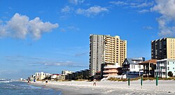
Miramar Beach, Florida
| Miramar Beach, Florida | |
|---|---|
| CDP | |

Oceanfront at Miramar Beach, Florida, September 2014.
|
|
 Location in Walton County and the state of Florida |
|
| Coordinates: 30°22′58″N 86°21′21″W / 30.38278°N 86.35583°WCoordinates: 30°22′58″N 86°21′21″W / 30.38278°N 86.35583°W | |
| Country |
|
| State |
|
| County | Walton |
| Area | |
| • Total | 4.7 sq mi (12.2 km2) |
| • Land | 4.6 sq mi (11.9 km2) |
| • Water | 0.1 sq mi (0.3 km2) |
| Elevation | 20 ft (6 m) |
| Population (2010) | |
| • Total | 6,146 |
| • Density | 518.1/sq mi (199.6/km2) |
| Time zone | Central (CST) (UTC-6) |
| • Summer (DST) | CDT (UTC-5) |
| ZIP code | 32550 |
| Area code(s) | 850 |
| FIPS code | 12-46000 |
| GNIS feature ID | 0286975 |
Miramar Beach is a census-designated place (CDP) in Walton County, Florida, United States. The population was 6,146 at the 2010 census. Although many other localities in Florida have appended "Beach" to their names to distinguish themselves from an adjacent inland or cross-bay municipality – such as Miami Beach, St. Pete Beach, Pensacola Beach, Melbourne Beach, Cocoa Beach, and Jacksonville Beach – the city of Miramar, Florida is actually over 600 miles (970 km) away in South Florida. There are other Miramar Beaches in Goa, India and in Santa Barbara, California.
Miramar Beach is located at 30°22′58″N 86°21′21″W / 30.38278°N 86.35583°W (30.382698, -86.355962).
According to the United States Census Bureau, the total area of 4.7 square miles (12 km2), of which 4.6 square miles (12 km2) is land and 0.1 square miles (0.26 km2) (2.54%) is water.
As of the census of 2000, there were 2,435 people, 1,214 households, and 713 families residing in the CDP. The population density was 529.6 people per square mile (204.4/km²). There were 6,558 housing units at an average density of 1,426.3/sq mi (550.4/km²). The racial makeup of the CDP was 96.63% White, 0.62% African American, 0.70% Native American, 0.94% Asian, 0.21% from other races, and 0.90% from two or more races. Hispanic or Latino of any race were 1.36% of the population.
...
Wikipedia
