Mira Loma, California
| Mira Loma | |
|---|---|
| Former census-designated place | |
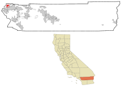
 Location in Riverside County and the state of California |
|
| Location in the United States | |
| Coordinates: 33°59′05″N 117°30′55″W / 33.98472°N 117.51528°WCoordinates: 33°59′05″N 117°30′55″W / 33.98472°N 117.51528°W | |
| Country |
|
| State |
|
| County | Riverside |
| Incorporated into Jurupa Valley | July 1, 2011 |
| Area | |
| • Total | 8.149 sq mi (21.107 km2) |
| • Land | 7.997 sq mi (20.712 km2) |
| • Water | 0.152 sq mi (0.395 km2) 1.87% |
| Elevation | 722 ft (220 m) |
| Population (2010) | |
| • Total | 21,930 |
| • Density | 2,700/sq mi (1,000/km2) |
| Time zone | PST (UTC-8) |
| • Summer (DST) | PDT (UTC-7) |
| ZIP code | 91752 |
| Area code(s) | 951 |
| FIPS code | 06-47976 |
| GNIS feature ID | 1656568 |
Mira Loma, now officially part of Jurupa Valley, was a census-designated place (CDP) in Riverside County, California, United States. Its population was 21,930 in the 2010 census, up from 17,617 in the 2000 census.
Mira Loma was known as Wineville prior to 1930. The name was changed that year to help disassociate the community from the Wineville Chicken Coop Murders.
In 2010, parts of Mira Loma became part of the newly incorporated city of Eastvale, California.
On July 1, 2011, parts of Mira Loma became part of the newly incorporated city of Jurupa Valley, California.
According to the United States Census Bureau, the CDP has a total area of 8.1 square miles (21 km2), of which, 8.0 square miles (21 km2) of it is land and 0.2 square miles (0.52 km2) of it (1.87%) is water.
Rancho Jurupa/Jurupa Valley was originally granted by the Mexican government to Sn. Dn. Juan Bandini, on September 28, 1838.
Originally known as Wineville, it is located in the modern day "Jurupa" area of unincorporated Riverside County. It is separated from the city of Riverside by the Santa Ana River to the south, borders the Ontario/Fontana area of San Bernardino County to the north and west, and Pedley / Glen Avon to the east. The community officially changed its name from Wineville on November 1, 1930, due in large part to the negative publicity surrounding the Wineville Chicken Coop Murders.
...
Wikipedia

