Minneopa State Park
| Minneopa State Park | |
| Minnesota State Park | |
|
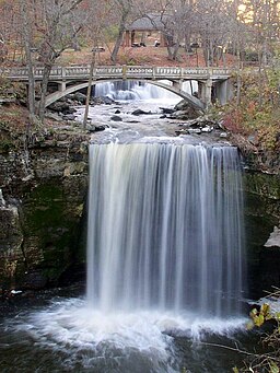
Upper and Lower Minneopa Falls
|
|
| Country | United States |
|---|---|
| State | Minnesota |
| County | Blue Earth |
| Location | Mankato |
| - elevation | 856 ft (261 m) |
| - coordinates | 44°9′44″N 94°6′8″W / 44.16222°N 94.10222°WCoordinates: 44°9′44″N 94°6′8″W / 44.16222°N 94.10222°W |
| Area | 4,643 acres (1,879 ha) |
| Founded | 1905 |
| Management | Minnesota Department of Natural Resources |
|
Minneopa State Park WPA/Rustic Style Historic Resources
|
|

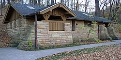
Example of a WPA/Rustic Style building in the park
|
|
| Location | South Bend Township, Blue Earth County, Minnesota |
|---|---|
| Nearest city | Mankato, Minnesota |
| Area | 58 acres (23 ha) |
| Built | 1937–1940 |
| Architectural style | National Park Service rustic |
| MPS | Minnesota State Park CCC/WPA/Rustic Style MPS |
| NRHP Reference # | 89001663 |
| Added to NRHP | October 25, 1989 |
Minneopa State Park is a state park in Minnesota, United States. It was established in 1905 to preserve Minneopa Falls, the largest waterfall in southern Minnesota, and was expanded in the 1960s to include the lower reaches of Minneopa Creek and a large tract of prairie. Minneopa is Minnesota's third oldest state park, after Itasca and Interstate. Two park resources are listed on the National Register of Historic Places: the 1862 Seppman Mill and a district of seven Rustic Style structures built by the Works Progress Administration in the late 1930s. The park is located almost entirely on the south side of the Minnesota River, 3 miles (4.8 km) west of Mankato. In 2015 the state reintroduced American bison to the park in a 330-acre (130 ha) fenced enclosure, which visitors can drive through in their vehicles.
Minneopa State Park is divided into two distinct sections by a corridor of roads, railroads, and private property. The original section contains the falls and Rustic Style structures. The much larger northern section, added in 1969, stretches along the Minnesota River and includes the campground and Seppmann Mill. Although the sections are contiguous, the only way to travel from one to the other is via a county road.
Minneopa Creek drains a small watershed in Blue Earth County and a small part of eastern Brown County. Most of its 11 miles (18 km) flow through farmland before entering the park. 2.2 miles (3.5 km) upstream from its mouth, Minneopa Creek flows over two waterfalls. The creek cascades about 6 or 7 feet (2 m) over the upper falls and flows 66 feet (20 m) before dropping over the 39-foot (12 m) lower falls. The name is a shortening of Minneinneopa, which is translated from the Dakota language as "water falling twice." Other translations have been given as "water of two falls" and "water of the dancing elk." Although Minneopa Falls is often referred to as the highest waterfall in southern Minnesota, Minnemishinona Falls in a nearby Nicollet County park is slightly higher at 42 feet (13 m) but is not as scenic or well-known. Lower Minneopa Falls can be called the region's largest, as it is 25 feet (7.6 m) wide while Minnemishinona spans only 10 feet (3.0 m).
...
Wikipedia


