Mines of Spain State Recreation Area and E. B. Lyons Nature Center
| Mines of Spain State Recreation Area and E. B. Lyons Nature Center | |
| Iowa State Park | |
|
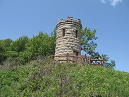
Julien Dubuque's monument
|
|
| Named for: Julien Dubuque's Mines | |
| Country | |
|---|---|
| State | |
| County | Dubuque |
| Location | Dubuque |
| - elevation | 751 ft (229 m) |
| - coordinates | 42°27′45″N 90°39′45″W / 42.46250°N 90.66250°WCoordinates: 42°27′45″N 90°39′45″W / 42.46250°N 90.66250°W |
| Area | 1,380 acres (558 ha) |
| Founded | 1981 |
| Management | Iowa Department of Natural Resources |
|
Julien Dubuque's Mines
|
|
| Built | 1897 |
|---|---|
| Architect | Alexander Simplot; Carter Bros. |
| Architectural style | Late Gothic Revival |
| MPS | Mines of Spain Archeological MPS |
| NRHP reference # | 88002662 |
| Significant dates | |
| Added to NRHP | November 21, 1988 |
| Designated NHLD | November 04, 1993 |
The Mines of Spain State Recreation Area and E. B. Lyons Nature Center is a state park in Dubuque County, Iowa, USA. It is near Dubuque, the eighth-largest city in the state. The park features picnic areas, 15 miles (24 km) of walking/hiking trails, 4 miles (6.4 km) of ski trails, and the Betty Hauptli Bird and Butterfly Garden. It also includes archaeological sites of national importance as an early lead mining and smelting venture led by French explorer Julien Dubuque, as well as Dubuque's gravesite. These sites were collectively designated a National Historic Landmark District as Julien Dubuque's Mines.
Meskwaki Indians were believed to be the first people in the area, residing in the area for up to 8000 years previous to discovery by Julien Dubuque, believed to be the first European to set foot in Iowa. The Meskwaki had been trading furs with French Voyageurs, as well as mining lead in the area. The Governor of Spain gave Dubuque a grant to work Spanish-owned land, naming the 1,380-acre (560 ha) area The Mines of Spain. Mining would continue by the Meskwaki, then by European settlers until 1914. These activities left a complex of archaeological sites, including prehistoric native settlement sites, the mining village of the Meskwaki, Dubuque's trading post, the mining areas themselves, and later mining-related areas.
From a horseshoe-shaped area, Horseshoe Bluff, the geology of the area is visible. Ordovician dolomite is evident, and two trails lead to a blind.
...
Wikipedia


