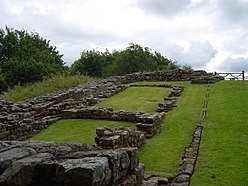
Milecastle 48
| Milecastle 48 | |
|---|---|

The remains of Milecastle 48
|
|
| Type | Milecastle |
| Province | Britannia |
| — Stone structure — | |
| Size and area | 18.5 m x 21.3 m (0.04 ha) |
| Coordinates | 54°59′20″N 2°34′24″W / 54.988991°N 2.573425°W |
| County | Cumbria |
| Country | England |
| UK-OSNG reference | NY6340666195 |
Milecastle 48 (Poltross Burn), is a milecastle on Hadrian's Wall (grid reference NY6340666195).
Milecastle 48 is situated just outside the village of Gilsland in Cumbria immediately adjacent to the Tyne Valley Line (grid reference NY6340666195). It has been known locally as "The King's Stables" for over 100 years but recently the heritage industry has begun to call it Poltross Burn Milecastle. The monument is currently in the care of English Heritage.
The milecastle measures 18.5 metres east to west by 21.3 metres north to south, substantially larger than many other milecastles. Two rows of buildings are visible within, probably barracks, one either side of the north-south road running through the gateways. Interior buildings are not normally so well-preserved or substantial in other milecastles and local people, "mining" the milecastle for building stone in the past, may have recognised the layout as similar to stable-blocks. The walls are broad gauge, including stub 'wing walls' which connect with the Narrow Wall curtain of Hadrian's Wall on either side. It has Type III gateways and lies 1521m west of Milecastle 47 and 1458m east of Milecastle 49.
...
Wikipedia

