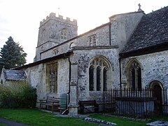
Mildenhall, Wiltshire
| Mildenhall | |
|---|---|
 St. John the Baptist parish church |
|
| Mildenhall shown within Wiltshire | |
| Population | 477 (2011 census) |
| OS grid reference | SU210696 |
| Civil parish |
|
| Unitary authority | |
| Ceremonial county | |
| Region | |
| Country | England |
| Sovereign state | United Kingdom |
| Post town | Marlborough |
| Postcode district | SN8 |
| Dialling code | 01672 |
| Police | Wiltshire |
| Fire | Dorset and Wiltshire |
| Ambulance | South Western |
| EU Parliament | South West England |
| UK Parliament | |
| Website | Community Site |
Mildenhall (/ˈmaɪnəl/ MY-nəl) is a village and civil parish in the Kennet Valley in Wiltshire, England, about 1 mile (1.6 km) east of the market town of Marlborough. The parish contains three communities – the village of Mildenhall, and the hamlets of Poulton and Stitchcombe.
The toponym is derived from the Old English but the site has been occupied since the Roman occupation of Britain, when the fortress town of Cunetio stood at an important road junction on approximately the same site. No remains of this fortress are now standing, but are clearly visible on aerial photographs. The Cunetio Hoard of Roman coins was discovered here in 1978. The name of the River Kennet, which runs through Mildenhall, is thought to have been derived from the Roman name, which is also used on the village's coat-of-arms.
Cunetio was deserted as a Romano-British site in about AD 450, but the site was reoccupied in the Anglo-Saxon era and a West Saxon charter drawn up between 803 and 805 refers to this settlement in its first recognisably modern form as Mildanhald, meaning "a nook of land of a woman called Milde or a man called Milda". The village is again mentioned in Domesday Book in 1086 as Mildenhalle and the name has since undergone numerous subtle changes in spelling and pronunciation.
...
Wikipedia

