Midway, Alabama
| Midway, Alabama | |
|---|---|
| Town | |

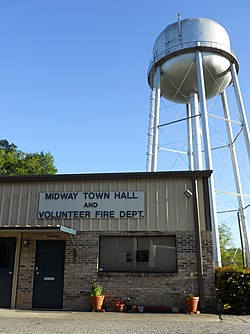
Midway Town Hall & Volunteer Fire Department
|
|
 Location in Bullock County and the state of Alabama |
|
| Coordinates: 32°4′28″N 85°31′13″W / 32.07444°N 85.52028°W | |
| Country | United States |
| State | Alabama |
| County | Bullock |
| Area | |
| • Total | 3.3 sq mi (8.6 km2) |
| • Land | 3.3 sq mi (8.6 km2) |
| • Water | 0 sq mi (0 km2) |
| Elevation | 538 ft (164 m) |
| Population (2010) | |
| • Total | 499 |
| • Density | 151/sq mi (58.2/km2) |
| Time zone | Central (CST) (UTC-6) |
| • Summer (DST) | CDT (UTC-5) |
| FIPS code | 01-48424 |
| GNIS feature ID | 0122703 |
Midway is a town located in eastern Bullock County, Alabama, United States. At the 2010 census the population was 499.
Margaret Elizabeth Merritt of Midway sold two acres for $5 to the State of Alabama in 1921 as a site for an elementary school for African-American children. Built in 1922 with matching Rosenwald funds, the Midway Colored Public School featured oak and pine construction and two classrooms divided by a partition. The building is one of the few surviving of the more than 5,000 rural black schools built with contributions for the Julius Rosenwald Fund. The building was enlarged twice then renovated in 1978. It is now used as a community center. It was added to the Alabama Register of Landmarks and Heritage on November 2, 1990 and the National Register of Historic Places on February 20, 1998.
The school is located in Bullock County. Bullock has the highest illiteracy rate of any county in Alabama.
Midway is located in eastern Bullock County at 32°4'27.854" North, 85°31'12.857" West (32.074404, −85.520238).
According to the U.S. Census Bureau, the town has a total area of 1.6 square miles (4.1 km2), all land.
Midway is located on the U.S. Route 82, the Jefferson Davis Highway, 13 miles (21 km) east of Union Springs, the county seat. It is 27 miles (43 km) east to Eufaula via US-82. Alabama State Route 51 leads south 16 miles (26 km) to Clayton.
...
Wikipedia
