Midgham
| Midgham | |
|---|---|
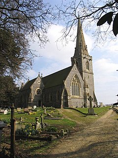
 St Matthew's parish church was built in 1869 in a tall 13th-century style. |
|
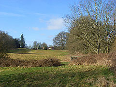
 View of upper part of Midgham Park estate. |
|
| Midgham shown within Berkshire | |
| Area | 5.01 km2 (1.93 sq mi) |
| Population | 334 (2011 census) |
| • Density | 67/km2 (170/sq mi) |
| OS grid reference | SU5567 |
| Civil parish |
|
| Unitary authority | |
| Ceremonial county | |
| Region | |
| Country | England |
| Sovereign state | United Kingdom |
| Post town | Reading |
| Postcode district | RG7 |
| Dialling code | 0118 |
| Police | Thames Valley |
| Fire | Royal Berkshire |
| Ambulance | South Central |
| EU Parliament | South East England |
| UK Parliament | |
| Website | The Midgham Village Website |
Midgham is a village and civil parish occupying slopes and the alluvial plain on the north side of the Kennet. It is centred 6 miles (10 km) east of Newbury, Berkshire and 2 miles (3.2 km) east of Thatcham. The north of the parish is 4.5 miles (7 km) south of the M4 motorway. Midgham Lock is on the Kennet and Avon canal which in summer months draws much of the water from the valley. It has smaller watercourses alongside. Its elevations range from 60 to 121 metres above sea level. Midgham Wood covers most of the north-west and Channel Wood covers most of the north-east eighth of the parish. The vast majority of the other green space is cultivated land, pasture or hay meadows. The lowland area of lakes, river and canal is greater than that covered by roads across the whole parish, as at the 2005 Office for National Statistics survey.
Midgham House or Midgham Park in the centre of the area is a building which is not listed but which has a double 15th-century red-brick former stable block with later additions and is at the top of a landscaped private park.
The village extends New Road Hill, Woolhampton Lock in the east, West Berkshire Crematorium in the west, Midgham Marsh (south of the A4 road) in the south and to Midgham Green to the north.
For no recorded other reasons, other than confusion with Wolverhampton, the station in Woolhampton 100m east of the area's bounds (which is therefore the nearest station to all but the far western borders of Midgham), changed its name to Midgham railway station in 1873. This station is a minor stop with regular services on the London to Exeter (via Taunton) Line. The stationmaster became frustrated by frequently redirecting wrongly-addressed packages intended for a very large town with station, Wolverhampton.
...
Wikipedia

