Midford
| Midford | |
|---|---|
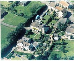
 aerial view of Midford |
|
| Midford shown within Somerset | |
| OS grid reference | ST761607 |
| Unitary authority | |
| Ceremonial county | |
| Region | |
| Country | England |
| Sovereign state | United Kingdom |
| Post town | BATH |
| Postcode district | BA2 |
| Dialling code | 01225 |
| Police | Avon and Somerset |
| Fire | Avon |
| Ambulance | South Western |
| EU Parliament | South West England |
| UK Parliament | |
Midford is a village approximately 3 miles (5 km) miles south south east of Bath, Somerset, England. Although relatively small, it extends over 2 counties (Wiltshire and Somerset), is part of two unitary authorities (Wiltshire and Bath and North East Somerset) and is part of five parishes (Southstoke, Hinton Charterhouse, Wellow, Freshford and Limpley Stoke). Although all five parishes extend very near to the village centre, most of the residents reside in the parish of Southstoke and are part of the Bath and North East Somerset unitary authority.
The Cam and Wellow Brooks merge in Midford to form the Midford Brook, which then flows down to join the River Avon close to the village of Monkton Combe.
In the village, straddling the B3110 road, is the disused viaduct of the Somerset and Dorset Joint Railway and close by are the remains of a lesser viaduct that once carried the Somerset Coal Canal, and later the Great Western branch line from Limpley Stoke to Hallatrow. Midford railway station, on the S&DJR line served the village until 1966. That line is now on the route of NCR 24, the Colliers Way.
For about four years from 1911 to 1915, Midford had a second railway station: Midford Halt railway station on the Limpley Stoke to Camerton railway that followed the former Somerset Coal Canal. At Camerton it made an end-on junction with a branch from Hallatrow on the former Bristol & North Somerset Railway. The line was open to passenger traffic for only seven years in all, from 1910 to 1915, and from 1923 to 1925. Midford Halt opened a year late and then did not reopen for the second period. Midford Halt was in Wiltshire; the county boundary runs up to the B3110 road at the point where the canal/railway crossed the road, and the halt was on the Wiltshire side.
...
Wikipedia

