Mickleham, Surrey
| Mickleham | |
|---|---|
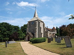
 St. Michaels church |
|
| Mickleham shown within Surrey | |
| Area | 7.31 km2 (2.82 sq mi) |
| Population | 585 (Civil Parish 2011) |
| • Density | 80/km2 (210/sq mi) |
| OS grid reference | TQ171534 |
| Civil parish |
|
| District | |
| Shire county | |
| Region | |
| Country | England |
| Sovereign state | United Kingdom |
| Post town | Dorking |
| Postcode district | RH5 |
| Dialling code | 01372 or 01306 |
| Police | Surrey |
| Fire | Surrey |
| Ambulance | South East Coast |
| EU Parliament | South East England |
| UK Parliament | |
Mickleham is a village and civil parish between the towns of Dorking and Leatherhead in Surrey, England covering 7.31 square kilometres (1,810 acres). The parish includes the hamlets of Fredley and Westhumble.
Mickleham lies near to the old Roman road known as Stane Street. Then, acquiring its Old English based name, the small settlement lay within the Copthorne hundred used for meetings of the wealthy and powerful for strategic purposes in Anglo-Saxon England.
Mickleham appears in Domesday Book of 1086 as Michelham and Micleham. It was partly held by Nigel from the Bishop of Bayeux and partly by Oswald from (under) Richard de Tonbridge. Its domesday assets were: 7 hides; 1 church, 7 ploughs, 3 acres (12,000 m2) of meadow, woodland worth 4 hogs. It rendered £10 per year to its overlords.
Nearby Mickleham Down was the venue for a single wicket cricket match on Monday, 29 June 1730. The game was between two teams of three and played for a substantial stake of £50. The teams, Surrey and Sussex, were described in a contemporary newspaper report as "esteemed the best in the respective counties" but it does not name the players. The Sussex three won the match. This is the first and only reference to Mickleham in association with cricket of a senior level.
...
Wikipedia

