Miami River (Florida)
| Miami River | |
|---|---|

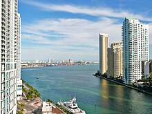
The mouth of the Miami River at Brickell Key
(February 2010). |
|
| Country | United States |
| Basin | |
| Main source |
The Everglades Sea level |
| River mouth |
Brickell Point 25°46′14″N 80°11′06″W / 25.7705°N 80.1851°WCoordinates: 25°46′14″N 80°11′06″W / 25.7705°N 80.1851°W |
| Basin size | 2,800 sq mi (7,300 km2) |
| Physical characteristics | |
| Length | 5.5 mi (8.9 km) |
| Discharge |
|
The Miami River is a river in the United States state of Florida that drains out of the Everglades and runs through the city of Miami, including Downtown. The 5.5-mile (8.9 km) long river flows from the terminus of the Miami Canal at Miami International Airport to Biscayne Bay. It was originally a natural river inhabited at its mouth by the Tequesta Indians, but it was dredged and is now polluted because of its route through Miami-Dade County. The mouth of the river is now home to the Port of Miami and many other businesses whose pressure to maintain it has helped to improve the river's condition.
Although it is widely believed that the name is derived from a Native American word that means "sweet water", the earliest mention of the name comes from Hernando de Escalante Fontaneda, a captive of Indians in southern Florida for 17 years, when he referred to what is now Lake Okeechobee as the "Lake of Mayaimi, which is called Mayaimi because it is very large". The Mayaimi Indians were named after the lake, beside which they lived. Spanish records include the cacique of 'Maimi' in a group of 280 Florida Indians that arrived in Cuba in 1710. Reports on a Spanish Mission to the Biscayne Bay area in 1743 mention 'Maymies' or 'Maimíes' living nearby. The river has also been known as the Garband River, Rio Ratones, Fresh Water River, Sweetwater River, and Lemon River. It has been known as the Miami River since the Second Seminole War of 1835–42.
In its original natural state, the river started at rapids formed by water from the Everglades flowing over a rocky ledge four miles (6.4 km) from its mouth. Frederick H. Gerdes of the U.S. Coast Survey reported in 1849 that "[f]rom the upper falls to near its entrance into Key Biscayne Bay… water in the Glades was 6 feet 2.5 inches (1.892 m) above low tide." The rapids were removed when the Miami Canal was dredged in an attempt to drain the wetland.
...
Wikipedia
