Messenia Prefecture
|
Messinia Περιφερειακή ενότητα Μεσσηνίας |
|
|---|---|
| Regional unit | |

Municipalities (dimi) of Messinia, 2010:
|
|
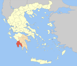
 Messenia within Greece |
|
| Coordinates: 37°10′N 22°0′E / 37.167°N 22.000°ECoordinates: 37°10′N 22°0′E / 37.167°N 22.000°E | |
| Country | Greece |
| Region | Peloponnese |
| Capital | Kalamata |
| Area | |
| • Total | 2,991 km2 (1,155 sq mi) |
| Population (2011) | |
| • Total | 159,954 |
| • Density | 53/km2 (140/sq mi) |
| Postal codes | 24x xx |
| Area codes | 272x0, 276x0 |
| ISO 3166 code | GR-17 |
| Car plates | ΚΜ |
Messenia (/məˈsiːniə, -ˈsiːnjə/; Greek: Μεσσηνία Messinia, pronounced [mesiˈnia]) is a regional unit (perifereiaki enotita) in the southwestern part of the Peloponnese, one of 13 regions into which Greece has been divided by the Kallikratis plan, implemented 1 January 2011. Before 2011 Messenia was a nomos (prefecture). The capital and the biggest city of Messenia in either case has been the city of Kalamata.
Messenia borders on Elis to the north, Arcadia to the northeast, and Laconia to the southeast. The Ionian Sea lies to the west, and the Gulf of Messenia to the south. The most important mountain ranges are the Taygetus in the east, the Kyparissia mountains in the northwest and the Lykodimo in the southwest. The main rivers are the Neda in the north and the Pamisos in central Messenia.
...
Wikipedia
