Melton Hill Dam
| Melton Hill Dam | |
|---|---|

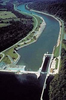
Melton Hill Lock and Dam. View is downriver to the west. The Tennessee Route 95 bridge can be seen downriver.
|
|
| Official name | Melton Hill Dam |
| Location | Roane County and Loudon County, Tennessee, United States |
| Coordinates | 35°53′7″N 84°18′0″W / 35.88528°N 84.30000°WCoordinates: 35°53′7″N 84°18′0″W / 35.88528°N 84.30000°W |
| Construction began | September 6, 1960 |
| Opening date | May 1, 1963 |
| Operator(s) | Tennessee Valley Authority |
| Dam and spillways | |
| Impounds | Clinch River |
| Height | 103 feet (31 m) |
| Length | 1,020 feet (310 m) |
| Reservoir | |
| Creates | Melton Hill Lake |
| Power station | |
| Turbines | 2 |
| Installed capacity | 72 MW |
Melton Hill Dam is a hydroelectric dam on the Clinch River just south of Oak Ridge, Tennessee, United States. The dam is operated by the Tennessee Valley Authority, which built the dam in the early 1960s to extend the Tennessee Valley's continuous navigation channel up the Clinch as far as Clinton and to increase TVA's overall power-generating capacity. The dam impounds the 5,470-acre (2,210 ha) Melton Hill Lake, and is the only TVA tributary dam serviced by a navigation lock.
Melton Hill Dam was named for a knob atop nearby Copper Ridge where the U.S. Coast and Geodetic Survey installed a triangulation station in 1884.
The Clinch River flows southwestward for 300 miles (480 km) from its source in southwestern Virginia through the hills of northeastern Tennessee before emptying into the Tennessee River at Kingston. Melton Hill Dam is located 23 miles (37 km) upstream from the mouth of the Clinch, stretching across the Roane-Loudon county line. Melton Hill's tailwaters are part of Watts Bar Lake, a main Tennessee River channel impoundment that extends across the lower 23 miles (37 km) of the Clinch. Melton Hill is the newer of two dams on the lower Clinch, the other being Norris Dam, located 56 miles (90 km) upstream from Melton Hill.
Melton Hill is a concrete gravity-type dam with an electric power generation capacity of 79 megawatts. The dam is 103 feet (31 m) high and stretches 1,020 feet (311 m) across the Clinch River. The dam is equipped with a 3-bay spillway that has a total discharge of 118,000 cubic feet (3,341 cubic meters) per second.
...
Wikipedia
