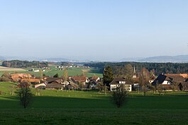
Meikirch
| Meikirch | ||
|---|---|---|

Meikirch village
|
||
|
||
| Coordinates: 47°0′N 7°22′E / 47.000°N 7.367°ECoordinates: 47°0′N 7°22′E / 47.000°N 7.367°E | ||
| Country | Switzerland | |
| Canton | Bern | |
| District | Bern-Mittelland administrative district | |
| Area | ||
| • Total | 10.23 km2 (3.95 sq mi) | |
| Elevation | 654 m (2,146 ft) | |
| Population (Dec 2015) | ||
| • Total | 2,386 | |
| • Density | 230/km2 (600/sq mi) | |
| Postal code | 3045 | |
| SFOS number | 0307 | |
| Surrounded by | Kirchlindach, Schüpfen, Seedorf, Wohlen bei Bern | |
| Website |
www SFSO statistics |
|
Meikirch is a municipality in the administrative district of Bern-Mittelland in the canton of Bern in Switzerland.
Meikirch is first mentioned in 1208 as Mönchilcha.
Evidence of prehistoric settlements in Meikirch include rich Hallstatt sites in Grächwil and a Roman estate with wall paintings in Meikirch. The modern village was first settled and owned by the Monastery of Frienisberg. During the 13th and 14th centuries, the village was owned by the Bernburg family of Bolligen. During the 16th century, it was owned by the hereditary Schultheiss family of Aarberg, the Aebischers. In 1555 the Aebischer family sold the village to the city of Bern.
The village church was first mentioned in 1275, but was built in the 7th and 8th century on top of the ruins of a Roman villa. Portions of the early medieval and medieval churches have been preserved in spite of later alterations. The church tower is from the 12th century. In 1528, after the Protestant Reformation, the church came under the authority of Bern.
After the 1798 French invasion, it became part of the District of Zollikofen. Five years later, after the collapse of the Helvetic Republic, it was placed in the District of Aarberg. The municipality was on the old Bern-Frienisberg-Aarberg road and during the 18th and 19th centuries was part of the postal route between those towns. In 1851-52 a new road was built between Wohlen and Frieswil which bypassed Meikirch. The population began to decline after 1850 and the rate increased after World War I. During this time, the local farms changed from grain farming to cattle and dairy farming, which required fewer people and drove villagers away from Meikirch. The decline stopped with improved transport infrastructure, including the 1948 Postauto route to Bern. The population began to increase when, in 1960, a new road to Bern was completed. The old village houses were rebuilt and the new developments of Schützenrain, Weissenstein and Neu-Grächwil were built to provide housing for new residents. The Meikirch secondary school was founded in 1974.
...
Wikipedia


