Medora Site

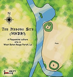
Diagram of the Medora Site
|
|
| Location |
Plaquemine, Louisiana, West Baton Rouge Parish, Louisiana, |
|---|---|
| Region | West Baton Rouge Parish, Louisiana |
| Coordinates | 30°19′36.34″N 91°12′5.65″W / 30.3267611°N 91.2015694°W |
| History | |
| Founded | 1300 CE |
| Cultures | Plaquemine culture |
| Site notes | |
| Excavation dates | 1939-1940 |
| Archaeologists | Dr. James A. Ford, George I. Quimby |
| Architecture | |
| Architectural styles | Platform mounds, Plaza |
| Responsible body: private | |
The Medora Site (16WBR1) is an archaeological site that is a type site for the prehistoric Plaquemine culture period. The name for the culture is taken from the proximity of Medora to the town of Plaquemine, Louisiana. The site is in West Baton Rouge Parish, Louisiana, and was inhabited from approximately 1300 to 1600 CE. It consisted of two mounds separated by a plaza. In the winter of 1939-40 excavation of this site was undertaken by the Louisiana State Archaeological Survey, a joint project of Louisiana State University and the Work Projects Administration. It was directed by Dr. James A. Ford, and George I. Quimby. The excavations of the site were instrumental in defining the characteristics of the Plaquemine period and culture.
The Medora Site is located in West Baton Rouge Parish, Louisiana adjacent to Bayou Bourbeaux (or Bourbeau or Bourbaux) on the flood plain of Manchac Point (also called Australia Point). Manchac Point is a hair-pin bend of the Mississippi River. Bayou Bourbeaux, a point stream which flows away from the river to the west, drains the back slopes of the natural levees that border Manchac Point, and connects with Bayou Gross Tete. The land surrounding the site is wet and subject to annual flooding, being only twenty feet above sea level. The site is part of the Medora Plantation, after which it is named, and had been cultivated for many years prior to the excavation.
It was possible to date the site by geological and archaeological means and obtain an estimate of the period of time in which the site was occupied. According to the Louisiana Geological Survey abandoned river course maps of Harold Norman Fisk, a meander of the Mississippi River began migrating from north to south across the area now occupied by Manchac Point at stage 9 (900 CE). The land of which Manchac Point is composed was not built up behind the meander until the beginning of stage 13 (1300 CE), meaning it was not suitable for habitation until then. And since all artifacts found at the site were from the Plaquemine period and not the succeeding Natchez period which begins in 1700, the dates for occupation are approximately from 1300 to 1600 CE.
...
Wikipedia

