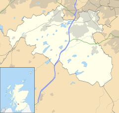
Mearns, Renfrewshire
Newton Mearns
|
|
|---|---|
 Paidmyre Road |
|
| Newton Mearns shown within East Renfrewshire | |
| Population | 22,637 |
| OS grid reference | NS536556 |
| Council area | |
| Lieutenancy area | |
| Country | Scotland |
| Sovereign state | United Kingdom |
| Post town | GLASGOW |
| Postcode district | G77 |
| Dialling code | 0141 |
| Police | Scottish |
| Fire | Scottish |
| Ambulance | Scottish |
| EU Parliament | Scotland |
| UK Parliament | |
| Scottish Parliament | |
Newton Mearns (Scottish Gaelic: Baile Ùr na Maoirne [ˈpalə ˈuːɾ nə ˈmɯːrˠɲə]) is an affluent suburban town and the largest settlement in East Renfrewshire, Scotland. It lies 7 miles (11 km) southwest of Glasgow City Centre on the main road to Ayrshire, 410 feet (125 m) above sea level. It has a population of approximately 22,636, stretching from Whitecraigs to Mearnskirk.
It is part of the Greater Glasgow conurbation. Its name derives from being a new town of the Mearns (from Scottish Gaelic "a' Mhaoirne" meaning a stewartry).
Until the 20th century, the land around Newton Mearns was primarily agricultural. Ownership passed from the Pollocks (whose name is perpetuated in the nearby Glasgow housing estate of Pollok) to the Maxwells of Caerlaverock around 1300. It then passed to the Maxwells of Nether Pollok in 1648 and then the Stewarts of Blackhall in 1660. A new road from Eastwood Toll, now the main Ayr Road, was constructed in 1832. The 1893 'Ordnance Gazetteer of Scotland' describes it as "pleasantly situated on a rising ground 410 feet above sea-level". It also reveals that it was a 'burgh of barony' which bestowed the right to hold a weekly market and two annual fairs. However, the Gazetteer also describes the village as being only a "single street on the Glasgow and Kilmarnock highroad" By the end of the 18th century quarrying had developed and more importantly numerous textile mills and finishing works became established availing themselves of the numerous rivers and lochs for water supply.From the early 20th century, with the introduction of improved roads and railways to the area, it gradually became a growing commuter suburb of Glasgow. In the 1930s, between speculative and local authority housing ventures, a further 6,000 houses were added to the area and after a lull during the war years, in the 1950s, house building began again in earnest. Unfortunately, the old core village suffered neglect during and after WW2 and was all but derelict by the 1960s. It was purchased and turned into a shopping centre which was later to become 'The Avenue at Mearns' in 1991.
...
Wikipedia

