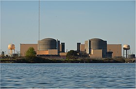
McGuire Nuclear Generating Station
| McGuire Nuclear Station | |
|---|---|

McGuire Nuclear Station from Lake Norman
|
|
| Country | United States |
| Location | Mecklenburg County, near Huntersville, North Carolina |
| Coordinates | 35°25′57″N 80°56′54″W / 35.43250°N 80.94833°WCoordinates: 35°25′57″N 80°56′54″W / 35.43250°N 80.94833°W |
| Status | Operational |
| Commission date | Unit 1: December 1, 1981 Unit 2: March 1, 1984 |
| Owner(s) | Duke Energy Corporation |
| Operator(s) | Duke Power Company |
| Nuclear power station | |
| Reactor type | pressurized water reactor |
| Reactor supplier | Westinghouse |
| Cooling source | Lake Norman |
| Cooling towers | no |
| Power generation | |
| Units operational | 2 x 1215 MW |
| Capacity factor | 91.4% |
| Annual output | 17,620 GWh |
|
Website www.duke-energy.com/.../mcguire |
|
The McGuire Nuclear Station is a nuclear power plant located about 17 miles (27 km) northwest of Charlotte, North Carolina, on the state's largest lake, Lake Norman. It is a 32,500-acre (13,200 ha) lake created in 1963 by Duke Power for the Cowans Ford Hydroelectric Station. The McGuire units use the lake's water for cooling.
This plant has two Westinghouse pressurized water reactors and has a capability to produce 2,250 megawatts of net power, with a net generation of 17,514 GW·h in 2005. This represents 44% of the total nuclear power generation for the state of North Carolina.
McGuire Nuclear Station is operated by Duke Power Company and owned by the Duke Energy Corporation. It is named for William McGuire, who served as president of Duke Power from 1959 to 1971.
The original operating licenses' dates of were 2021-06-12 for Unit 1 and 2023-03-03 for Unit 2. In 2003, the Nuclear Regulatory Commission (NRC) renewed the licenses for both reactors for an additional twenty years.
The NRC defines two emergency planning zones around nuclear power plants: a plume exposure pathway zone with a radius of 10 miles (16 km), concerned primarily with exposure to, and inhalation of, airborne radioactive contamination, and an ingestion pathway zone of about 50 miles (80 km), concerned primarily with ingestion of food and liquid contaminated by radioactivity.
The 2010 U.S. population within 10 miles (16 km) of McGuire was 199,869, an increase of 66.8 percent in a decade, according to an analysis of U.S. Census data for msnbc.com. The 2010 U.S. population within 50 miles (80 km) was 2,850,782, an increase of 23.3 percent since 2000. Cities within 50 miles include Charlotte (17 miles to city center).
The NRC's estimate of the risk each year of an earthquake intense enough to cause core damage to the reactor at McGuire was 1 in 32,258, according to an NRC study published in August 2010.
...
Wikipedia

