Mayne Island
| Mayne Island | |
|---|---|
| Island | |

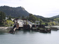
Village Bay, Mayne Island's ferry dock
|
|
 The Southern Gulf Islands, including Mayne. |
|
| Country | Canada |
| Province | British Columbia |
| Government | |
| • MP | Elizabeth May (Green Party of Canada) |
| • MLA | Gary Holman (BC NDP) |
| Area | |
| • Total | 21 km2 (8 sq mi) |
| Population | |
| • Total | 1,071 |
| Time zone | PST (UTC−8) |
| • Summer (DST) | PDT (UTC−7) |
Mayne Island is a 21-square-kilometre (8.1 sq mi) island in the southern Gulf Islands chain of British Columbia. It is situated midway between the Lower Mainland of BC and Vancouver Island, and has a population of 1071. Mount Parke in the south-central heart of the island is its highest peak at 255 meters (837 feet).
Originally, Mayne Island was inhabited by members of the Tsartlip First Nation, prior to European colonization. Several middens are present on the island, along with period articles — most notably including a 2 tonne stone bowl which was stolen in 1982 and again, in 2007.
In 1794 Captain George Vancouver camped on Georgina Point where his crew left a coin and a knife found over a century later by early settlers.
In 1857 Captain George Richards of the Royal Navy surveyed the area as captain of the Royal Navy vessel HMS Plumper, naming the island after his Lieutenant Richard Charles Mayne, son of the first commissioner of the London Metropolitan Police. His journals concerning his explorations of British Columbia are important sources for early British Columbia history, as are those of his colleague in many of those explorations, Royal Engineer Lieutenant Henry Spencer Palmer.
During the Fraser Canyon Gold Rush of 1858-1860 and after, Vancouver Island miners gathered on Mayne Island before rowing across Georgia Strait to the mainland of BC in search of their fortunes. The earliest homesteaders registered land claims in the Miners Bay area in 1859.
...
Wikipedia
