Maunabo
| Maunabo, Puerto Rico | ||
|---|---|---|
| Municipality | ||

|
||
|
||
| Nickname(s): "La Ciudad Tranquila", "Los Jueyeros", "Los Come Jueyes" | ||
| Anthem: "Maunabo pueblito del sureste de mi amada patria Borinquén" | ||
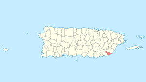
 Location of Maunabo in Puerto Rico |
||
| Coordinates: 18°00′25″N 65°53′57″W / 18.00694°N 65.89917°WCoordinates: 18°00′25″N 65°53′57″W / 18.00694°N 65.89917°W | ||
| Country | United States | |
| Territory | Puerto Rico | |
| Founded | 1799 | |
| Government | ||
| • Mayor | Jorge L. Márquez Pérez (PPD) | |
| • Senatorial dist. | 7 - Humacao | |
| • Representative dist. | 34 | |
| Area | ||
| • Total | 27.88 sq mi (72.21 km2) | |
| • Land | 21 sq mi (55 km2) | |
| • Water | 6.64 sq mi (17.21 km2) | |
| Population (2010) | ||
| • Total | 12,225 | |
| • Density | 440/sq mi (170/km2) | |
| Demonym(s) | Maunabeños | |
| Time zone | AST (UTC-4) | |
| Zip code | 00707 | |
Maunabo (Spanish pronunciation: [mauˈnaβo]) is a municipality of Puerto Rico located in the southeastern coast, northeast of Patillas and south of Yabucoa. Maunabo is spread over 8 wards and Maunabo Pueblo (The downtown area and the administrative center of the city). It is part of the San Juan-Caguas-Guaynabo Metropolitan Statistical Area.
The Mayor of the town is Jorge L. Márquez Pérez (PPD). This town has a population of 14,425. The Zip code of Maunabo is 00707.
With an almost unspoiled culture—due to the high mountains that separate the town from the rest—Maunabo still is a very colonial city and the lack of large commercial chains gives it a unique personality compared to the rest of the island.
Currently, the town is constructing the first tunnels of the island that go under the eastern side mountains connecting it with the neighboring town of Yabucoa. A Chilean construction company is in charge of the contract. The tunnels have been named Vicente Morales Lebrón, after an environmental activist who, as a result of the 1956 tropical storm Betsy that damaged the only road that connected the town with the north side of the island, proposed the tunnels to be built.
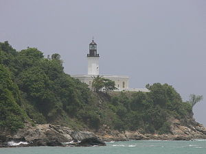
The warm, unspoiled and untamed blue and green waters of the beaches of Maunabo are one of its major attractions. The three beaches (Los Bohios, Los Pinos and Playa Punta Tuna) are mostly visited by the locals all year round. The beaches also attract tourists that explore other regions beyond San Juan and other major cities. Surfers love these wild and dangerous waters. The Punta Tuna beach is also known by the locals as Playa Escondida or the "hidden beach", crowned by the Punta Tuna Lighthouse on one side and separated from the main road by lush sea grape trees on the other. The beach is only accessible by foot through a short dusty road.
The sand at Los Pinos beach (the name means "the pines" and it comes from a pine-tree-lined hill on the side of the beach) shines with black carbon minerals and legend has it that these come from sea volcanoes or from underwater fossil fuel deposits. The minerals tend to stick to anything that is wet and thus it is rarely visited.
...
Wikipedia

