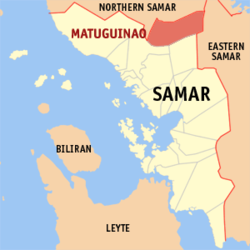
Matuguinao, Samar
| Matuguinao | |
|---|---|
| Municipality | |
 Map of Samar with Matuguinao highlighted |
|
| Location within the Philippines | |
| Coordinates: 12°09′N 124°53′E / 12.150°N 124.883°ECoordinates: 12°09′N 124°53′E / 12.150°N 124.883°E | |
| Country | Philippines |
| Region | Eastern Visayas (Region VIII) |
| Province | Samar |
| District | 1st district of Samar |
| Barangays | 20 |
| Government | |
| • Mayor | Melissa A. dela Cruz |
| • Vice Mayor | Carmel dela Cruz |
| Area | |
| • Total | 172.51 km2 (66.61 sq mi) |
| Population (2015 census) | |
| • Total | 7,288 |
| • Density | 42/km2 (110/sq mi) |
| Time zone | PST (UTC+8) |
| ZIP code | 6708 |
| IDD : area code | +63 (0)55 |
| Income class | 5th municipal income class |
| 086011000 | |
| Electorate | 5,281 voters as of 2016 |
| Website | elgu |
Matuguinao is a 5th class municipality in the province of Samar, Philippines. According to the 2015 census, it has a population of 7,288 people.
Matuguinao were named as a municipal district of Gandara in the year 1948 to 1960 and were converted into a municipality in 1965.
Matuguinao or Matugnaw is a word that literally means cold.
Matuguinao is politically subdivided into 20 barangays.
Water is abundant here in this town, it has cold and hot water source.
Garbage are being collected here manually by a karitilya, it is dumped on its garbage dumpsite right side along provincial road going to Matuguinao and after Barruz.
...
Wikipedia

