Matthew Town
| Matthew Town | |
|---|---|
 |
|
| Coordinates: 20°57′N 73°40′W / 20.950°N 73.667°WCoordinates: 20°57′N 73°40′W / 20.950°N 73.667°W | |
| Country |
|
| Island | Great Inagua |
| Population (2012) | |
| • Total | 430 |
| Time zone | Eastern Time Zone (UTC-5) |
| Area code(s) | 242 |
|
Bahamas
|
|
| Location | Southwest Point Matthew Town Inagua Bahamas |
|---|---|
| Coordinates | 20°56′00.7″N 73°40′27.4″W / 20.933528°N 73.674278°W |
| Year first constructed | 1870 |
| Construction | masonry tower |
| Tower shape | tapered cylindrical tower with balcony and lantern |
| Markings / pattern | white tower and lantern |
| Height | 34 metres (112 ft) |
| Focal height | 37 metres (121 ft) |
| Range | 22 nautical miles (41 km; 25 mi) |
| Characteristic | Fl (2) W 10s. |
| Admiralty number | J4804 |
| NGA number | 12360 |
| ARLHS number | BAH-007 |
| Managing agent | Bahamas Port Department |
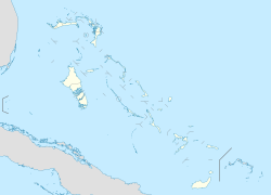
Matthew Town is the chief and only settlement on Great Inagua Island of the Bahamas. It is located on the southwest corner of the island. It was named after Bahamian Governor George Matthew (1844-1849) and first settled during his tenure in office. It has several buildings dating to the 19th century including the 1870 Great Inagua Lighthouse.
Almost the entire population of Inagua resides in Matthew Town (approx. 1000 people), and many of them are employed by the Morton Salt Company.
...
Wikipedia


