Matanuska River
| Matanuska River | |
|
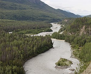
Silt-laden waters of the Chickaloon River (right center) enter the Matanuska River at mile 76 (km 123) of the Glenn Highway (upper right), a major highway connecting Anchorage to the rest of the state. The valley is forested with black cottonwood, balsam poplar, white spruce and paper birch.
|
|
| Country | United States |
|---|---|
| State | Alaska |
| Borough | Matanuska-Susitna |
| Source | confluence of the river's east and south forks |
| - elevation | 2,033 ft (620 m) |
| - coordinates | 61°47′27″N 147°29′07″W / 61.79083°N 147.48528°W |
| Mouth | Knik Arm, Cook Inlet |
| - location | 9.5 miles (15.3 km) southwest of Palmer |
| - elevation | 0 ft (0 m) |
| - coordinates | 61°29′49″N 149°16′11″W / 61.49694°N 149.26972°WCoordinates: 61°29′49″N 149°16′11″W / 61.49694°N 149.26972°W |
| Length | 75 mi (121 km) |
| Basin | 2,100 sq mi (5,439 km2) |
| Discharge | for Palmer |
| - average | 3,875 cu ft/s (110 m3/s) |
| - max | 82,100 cu ft/s (2,325 m3/s) |
| - min | 234 cu ft/s (7 m3/s) |
|
South-central Alaska, near Anchorage
|
|
The Matanuska River is a 75-mile (121 km) long stream in Southcentral Alaska, United States. The river drains a broad valley south of the Alaska Range eponymously known as the Matanuska Valley (Mat-Su Valley).
Formed by the confluence of its east and south forks, the Matanuska River flows generally southwest to the Knik Arm of Cook Inlet. Downstream of its source, the river is joined by meltwater from Matanuska Glacier in the northern Chugach Mountains. From there it continues through the Matanuska Valley, between the Chugach Mountains to the south and the Talkeetna Mountains to the north. Population centers along its course include Chickaloon, Sutton, Palmer, and Butte. It enters the Knik Arm of Cook Inlet about 9.5 miles (15.3 km) southwest of Palmer and about 25 miles (40 km) northeast of Anchorage.
The Glenn Highway runs roughly parallel to the river for much of its length. Highway bridges over the river, listed from source to mouth, include Glacier Park Bridge, Chickaloon River Bridge, King River Bridge, Old Glenn Highway Bridge, and Glenn Highway Bridge. An Alaska Railroad bridge crosses the river parallel to the Glenn Highway Bridge at Palmer Hay Flats State Game Refuge. Mantanuska Glacier State Recreation Site is along the highway where Glacier Creek enters the river; King Mountain State Recreation Site is near Chickaloon, and Kepler – Bradley Lakes State Recreation Area is near Palmer.
...
Wikipedia


