Matalam, Cotabato
| Matalam, Cotabato | ||
|---|---|---|
|
||
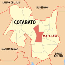
 Map of Cotabato with Matalam highlighted |
||
| Location within the Philippines | ||
| Coordinates: 7°05′N 124°54′E / 7.08°N 124.9°ECoordinates: 7°05′N 124°54′E / 7.08°N 124.9°E | ||
| Country | Philippines | |
| Region | SOCCSKSARGEN (Region XII) | |
| Province | Cotabato | |
| District | 3rd District of Cotabato | |
| Incorporated | December 29, 1961 | |
| Barangays | 34 | |
| Government | ||
| • Mayor | Oscar M. Valdevieso | |
| • Vice Mayor | Cheryl V. Catamco | |
| Area | ||
| • Total | 476.00 km2 (183.78 sq mi) | |
| Elevation | 80 m (260 ft) | |
| Population (2015 census) | ||
| • Total | 79,361 | |
| • Density | 170/km2 (430/sq mi) | |
| Time zone | PST (UTC+8) | |
| ZIP code | 9406 | |
| IDD : area code | +63 (0)64 | |
| Income class | 1st municipal income class | |
| 124708000 | ||
| Electorate | 42,599 voters (2016) | |
| Website | www |
|
Matalam is a first class municipality in the province of Cotabato, Philippines. According to the 2015 census, it has a population of 79,361 people.
Matalam is a palm shape municipality. It is centrally located right at the heart of the province of Cotabato. It is bounded on the east by the municipality of Kidapawan; on the west by Kabacan; on the south by M’lang and on the north by the Municipalities of President Roxas and Carmen. It lies along the Cotabato-Davao National Highway occupying the large portion of the Arakan Valley.
Matalam is politically subdivided into 34 barangays.
Matalam belongs to the 4th type of climate, which is characterized by a more or less even distribution of rainfall throughout the year. The municipality has an average rainfall of 13.63 inches (346 mm). The heaviest rainfall months of the year are May, June and July. The prevailing wind direction is from west to east. Matalam is geographically located outside typhoon belt. Normal condition temperature ranges from 28 to 38 °C (82 to 100 °F), the month of April being the hottest month, while the coldest month of the year is December.
The municipality of Matalam before its creation into a regular municipality was just a mere sitio of Kilada called "Crossing M'lang" within the jurisdiction of the municipality of Kabacan. Because of its strategic location coupled with the strong desire of the people, petitioned the provincial and national government for its creation into a regular municipality. It was formally separated from Kabacan and was created into a municipality in December 29, 1961 making Matalam as the 32nd Municipality of Cotabato. This municipality was named after the late illustrious father of the Province, Governor Datu Matalam, in acknowledgement of his untiring efforts for the development and creation of the place. MPDC Office_LGU-Matalam, Cotabato
In the 2015 census, the population of Matalam, Cotabato, was 79,361 people, with a density of 170 inhabitants per square kilometre or 440 inhabitants per square mile.
Matalam's market and other commercial establishments are the hub of activity in the area. Commercial establishments in the town include the following: bakeries, gasoline dealers, copra dealers, sari-sari stores, beta houses, carenderias, hardwares, grains retailers, fish dealers, and many more.
Rice, corn and copra are commodities which are very much in demand in the local trade. Due to lack of supply, rice and corn grits are sometimes brought in from the mainland. These are retailed in the market for local consumption.
...
Wikipedia


