Massachusetts Midstate Trail
| Midstate Trail | |
|---|---|

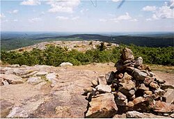
View from the Midstate Trail on Mount Watatic
|
|
| Length | 92 mi (148 km) |
| Location | Worcester County, Massachusetts |
| Use | hiking, snowshoeing, cross-country skiing, other |
| Elevation | |
| Highest point | Mount Wachusett, 2,006 ft (611 m) |
| Lowest point | French River, 470 ft (140 m) |
| Hiking details | |
| Trail difficulty | easy, with moderately difficult sections |
| Season | easiest spring to fall |
| Hazards | deer ticks, mosquitoes, weather, poison ivy, automobiles |
The Midstate Trail is a scenic footpath which runs 92 miles (148 km) through Worcester County, Massachusetts, from the Rhode Island border to the New Hampshire border, approximately 45 miles (72 km) west of Boston. The trail is considered highly accessible, scenic, and remarkably rural despite its proximity to urban Boston. The trail includes the summits of Mount Wachusett and Mount Watatic, as well as many interesting geologic, historic, and natural features.
The northern terminus of the Midstate Trail is located on the New Hampshire border on the Ashburnham/ Ashby, Massachusetts town line just north of the summit of Mount Watatic; the southern terminus is located on the Rhode Island border in Douglas, Massachusetts in Douglas State Forest. In Ashburnham, the Midstate Trail meets the Wapack Trail, which runs north into New Hampshire for an additional 21 miles (34 km). Where the Midstate Trail terminates on the Rhode Island border, the North-South Trail continues south 75 miles (121 km) to the Atlantic Ocean. The 22 miles (35 km) Southern New England Trunkline Trail, a converted rail trail, intersects the Midstate Trail in Douglas, Massachusetts, and there is a significant network of interconnecting shorter trails on Mount Wachusett and in the Ware River Watershed area maintained by the Massachusetts Department of Conservation and Recreation, the Worcester Chapter of the Appalachian Mountain Club, and the nonprofit organization Wachusett Greenways.
...
Wikipedia
