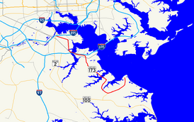
Maryland Route 173
| Maryland Route 173 | ||||
|---|---|---|---|---|

Maryland Route 173 highlighted in red
|
||||
| Route information | ||||
| Maintained by MDSHA and Baltimore DOT | ||||
| Length: | 13.78 mi (22.18 km) | |||
| Existed: | 1927 – present | |||
| Major junctions | ||||
| South end: | Fort Smallwood Park near Jacobsville | |||
|
|
||||
| North end: |
|
|||
| Location | ||||
| Counties: | Anne Arundel, City of Baltimore | |||
| Highway system | ||||
|
||||
![]() MD 607 in Jacobsville
MD 607 in Jacobsville![]() I-695 in Baltimore
I-695 in Baltimore![]() MD 710 in Baltimore
MD 710 in Baltimore
Maryland Route 173 (MD 173) is a state highway in the U.S. state of Maryland. Known for most of its length as Fort Smallwood Road, the state highway runs 13.78 miles (22.18 km) from Fort Smallwood Park near Jacobsville north to MD 2 in the Brooklyn neighborhood of Baltimore. MD 173 connects the beach communities of Riviera Beach and Orchard Beach in northeastern Anne Arundel County and Interstate 695 (I-695) with industrial areas in the Baltimore neighborhoods of Hawkins Point and Curtis Bay, including the United States Coast Guard Yard. MD 173 was mostly constructed in the 1920s and early 1930s. The state highway was put in its modern form with the completion of the bridge over Stony Creek in the late 1940s and expansion to a divided highway between Orchard Beach and Curtis Bay in the late 1970s.
...
Wikipedia

