Mary Esther, Florida
| Mary Esther, Florida | |
|---|---|
| City | |

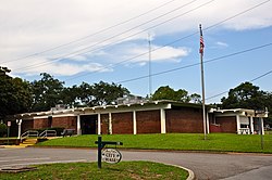
Mary Esther City Hall, September 2014.
|
|
| Motto: "A Growing Community " | |
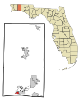
 Location in Okaloosa County and the state of Florida |
|
| Coordinates: 30°24′44″N 86°39′33″W / 30.41222°N 86.65917°WCoordinates: 30°24′44″N 86°39′33″W / 30.41222°N 86.65917°W | |
| Country |
|
| State |
|
| County | Okaloosa |
| Government | |
| • Type | Municipality |
| • Mayor | Christopher Stein |
| • Mayor Pro Tem | Danny Bennett |
| • Councilmember | Ron Sterns |
| • Councilmember | James W. Kitchens, Jr. |
| • Councilmember | Charlotte McKamy |
| Area | |
| • Total | 1.5 sq mi (4 km2) |
| • Land | 1.5 sq mi (4 km2) |
| • Water | 0 sq mi (0 km2) |
| Elevation | 23 ft (7 m) |
| Population (2010) | |
| • Total | 3,851 |
| • Density | 2,567.3/sq mi (962.75/km2) |
| Time zone | Central (CST) (UTC-6) |
| • Summer (DST) | CDT (UTC-5) |
| ZIP code | 32569 |
| Area code(s) | 850 |
| FIPS code | 12-43375 |
| GNIS feature ID | 0286480 |
Mary Esther is a city in Okaloosa County, Florida, United States. The population was 3,851 at the 2010 census. It is part of the Fort Walton Beach–Crestview–Destin Metropolitan Statistical Area.
Mary Esther gets its name from its first postmaster, John Newton, who named it for his daughters.
Mary Esther is located at 30°24′44″N 86°39′33″W / 30.412266°N 86.659044°W.
According to the United States Census Bureau, the city has a total area of 1.5 square miles (3.9 km2), all land.
Climate is characterized by relatively high temperatures and evenly distributed precipitation throughout the year. This climate type is found on the eastern sides of the continents between 20° and 35° N and S latitude. The Köppen Climate Classification subtype for this climate is "Cfa" (Humid Subtropical Climate).
As of the census of 2000, there were 4,055 people, 1,623 households, and 1,147 families residing in the city. The population density was 2,635.0 inhabitants per square mile (1,016.7/km²). There were 1,732 housing units at an average density of 1,125.5 per square mile (434.2/km²). The racial makeup of the city was 83.65% White, 6.46% African American, 0.96% Native American, 3.77% Asian, 0.17% Pacific Islander, 1.21% from other races, and 3.77% from two or more races. Hispanic or Latino of any race were 4.09% of the population.
...
Wikipedia
