Market Weighton Canal
| Market Weighton Canal | |
|---|---|

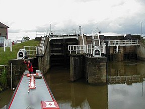
Weighton Lock at the entrance to the canal
|
|
| Specifications | |
| Locks | 4 |
| Status | Part navigable |
| Navigation authority | Environment Agency |
| History | |
| Date of act | 1772 |
| Date completed | 1782 |
| Date closed | 1971 |
| Geography | |
| Start point | below Market Weighton |
| End point | Broomfleet |
| Connects to | River Humber |
| Market Weighton Canal | |||||||||||||||||||||||||||||||||||||||||||||||||||||||||||||||||||||||||||||||||||||||
|---|---|---|---|---|---|---|---|---|---|---|---|---|---|---|---|---|---|---|---|---|---|---|---|---|---|---|---|---|---|---|---|---|---|---|---|---|---|---|---|---|---|---|---|---|---|---|---|---|---|---|---|---|---|---|---|---|---|---|---|---|---|---|---|---|---|---|---|---|---|---|---|---|---|---|---|---|---|---|---|---|---|---|---|---|---|---|---|
|
|||||||||||||||||||||||||||||||||||||||||||||||||||||||||||||||||||||||||||||||||||||||
The Market Weighton Canal ran 9.5 miles (15.3 km) from the Humber estuary to its terminus near Market Weighton. It gained its Act of Parliament in 1772 and opened in 1782. The 3.5 miles (5.6 km) closest to Market Weighton was abandoned in 1900 and the right of navigation through Weighton lock was lost in 1971. However, as of 2002 the lock was passable and the canal usable up to the junction with the River Foulness where silt has made it impassable. Also there is no right of navigation under the M62 motorway bridge to the north of Newport.
The canal was conceived as part of a wider scheme to drain the low-lying land and fens between the River Humber and Market Weighton. Some 50,000 acres (20,000 ha) of land were threatened by flooding, both from rain and from water flowing into the area from a larger catchment covering 80,000 acres (32,000 ha), including the East Yorkshire Wolds, which border the area to the east. Before the scheme, most of the lower area was marshland, while the upper area suffered from waterlogging, and was only suitable for grazing of animals. In 2012 the Market Weighton Drainage Board amalgamated with the neighbouring Lower Ouse Internal Drainage Board to form the Ouse and Humber Drainage Board. Along with its main tributary, the River Foulness which is managed and maintained by the Ouse and Humber Drainage Board, the canal is responsible for the land drainage and flood risk management of this heavily modified, man made landscape.
The first scheme was for a line from the Humber to Wholsea, near Sod House lock, with a branch to Pocklington and another to Weighton. It was proposed in October 1765, and again in August 1767. By April 1771, it had become a navigable drain, and by December, the branch to Pocklington had been dropped. The scheme eventually put before Parliament was for a new cut from Market Weighton to the River Foulness, which would be straightened from the junction to the Humber. The channel would be used as a canal and as a drain.
The scheme was authorised by an Act of Parliament of 21 May 1772, entitled, "An Act for draining and preserving certain Commons, Low Grounds, and Carrs, in the parish of Market Weighton, and other adjacent parishes in the East Riding of the County of York; and for making a navigable Cut or Canal, from Market Weighton to the River Humber." The Act did not include powers to raise capital, as a group of people had agreed to finance the initial construction, while ongoing revenue was to be provided by a tax on landowners who benefited from the drainage and by the enclosing of common land, in addition to the normal tolls. The engineer appointed to oversee the work was a Mr. Whitworth, and was managed by a committee of Drainage Commissioners.
...
Wikipedia
