Mariveles, Bataan
| Mariveles | |
|---|---|
| Municipality | |

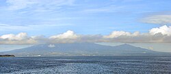
Mariveles seen from Manila Bay
|
|
 Location within Bataan province |
|
| Location within the Philippines | |
| Coordinates: 14°26′N 120°29′E / 14.43°N 120.48°ECoordinates: 14°26′N 120°29′E / 14.43°N 120.48°E | |
| Country | Philippines |
| Region | Central Luzon (Region III) |
| Province | Bataan |
| District | 2nd District |
| Founded | 1754 |
| Barangays | 18 (see Barangays) |
| Government | |
| • Type | Sangguniang Bayan |
| • Mayor | Ace Jello C. Concepcion (National Unity) |
| • Vice Mayor | Angelito S. Rubia (National Unity) |
| Area | |
| • Total | 153.90 km2 (59.42 sq mi) |
| Population (2015 census) | |
| • Total | 127,536 |
| • Density | 830/km2 (2,100/sq mi) |
| • Voter (2016) | 75,890 |
| Time zone | PST (UTC+8) |
| ZIP code | 2105 |
| IDD : area code | +63 (0)47 |
| Income class | 1st class |
| PSGC | 030807000 |
| Website | marivelesbataan |
Mariveles, officially the Municipality of Mariveles (Filipino: Bayan ng Mariveles; Kapampangan: Balen ning Mariveles), is a municipality in the province of Bataan in the Central Luzon (Region III) of the Philippines. The population was 127,536 at the 2015 census. In the 2016 electoral roll, it had 75,890 registered voters.
Founded as a pueblo by a Franciscan Friar in 1578, Mariveles, the "Village of Kamaya" was part of the Corregimiento of Mariveles, including Bagac and Morong, Corregidor and Maragondon, Cavite.
The Superior Decree of July 1754 declared Mariveles' independence from Pampanga.
In the 19th century, the Americans established the first quarantine station in the old Spanish Leprosarium Hospital (now, the Mariveles Mental Ward).
Mariveles is located at 14°26′N 120°29′E / 14.43°N 120.48°E in a cove at the southern tip of the Bataan Peninsula. It is 164 kilometres (102 mi) from Manila via the North Luzon Expressway, Gapan-Olongapo Road and Roman Highway.
...
Wikipedia

