Marina Del Ray
| Marina del Rey | |
|---|---|
| Census-designated place | |

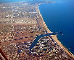
Aerial view of Marina del Rey, with Los Angeles International Airport and Palos Verdes Peninsula in the background.
|
|
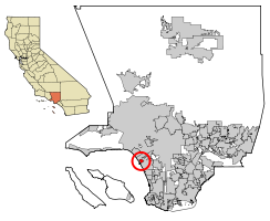
 Location of Marina del Rey in Los Angeles County, California and of Los Angeles County, California within California. |
|
| Location in the United States | |
| Coordinates: 33°58′46″N 118°27′10″W / 33.97944°N 118.45278°WCoordinates: 33°58′46″N 118°27′10″W / 33.97944°N 118.45278°W | |
| Country |
|
| State |
|
| County |
|
| Area | |
| • Total | 1.455 sq mi (3.768 km2) |
| • Land | 0.860 sq mi (2.226 km2) |
| • Water | 0.595 sq mi (1.541 km2) 40.91% |
| Elevation | 0 ft (0 m) |
| Population (2010) | |
| • Total | 8,866 |
| • Density | 6,100/sq mi (2,400/km2) |
| Time zone | Pacific (PST) (UTC-8) |
| • Summer (DST) | PDT (UTC-7) |
| ZIP codes | 90291–90292, 90295 |
| Area code | 310/424 |
| FIPS code | 06-45806 |
| GNIS feature ID | 1852255 |
Marina del Rey is an unincorporated seaside community and census-designated place (CDP) in Los Angeles County, California. A Westside locale, the population was 8,866 at the 2010 census. Fisherman's Village offers a view of Marina del Rey's dominant feature, the Marina, the world's largest man-made small craft harbor with eight basins having a capacity for 5,300 boats and is home port to approximately 6,500 boats. The harbor, the Los Angeles Times said in 1997, is "perhaps the county's most valuable resource".
Prior to its development as a small craft harbor, the land occupied by Marina del Rey was a salt-marsh fed by fresh water from Ballona Creek, frequented by duck hunters and few others. Burton W. Chace, a member of the Los Angeles County Board of Supervisors, referred to the area as mud flats, though today the area would more properly be referred to as wetlands.
In the mid-19th century, Moye C. Wicks and Louis Mesmer thought of turning this Playa del Rey estuary into a commercial port. He formed the Ballona Development Company in 1888 to develop the area, but three years later the company went bankrupt.
Port Ballona made by Louis Mesmer and Moye Wicks was then sold to Moses Sherman. Sherman purchased 1,000 acres (400 ha) of land around the Ballona lagoon and Port Ballona in 1902 under the name the Beach Land Company. Sherman and Clark renamed the land "Del Rey". Port Ballona was then renamed Playa Del Rey. The port was serviced by the California Central Railway opened in September 1887, this line later became the Santa Fe Railway, that later became the Atchison, Topeka, and Santa Fe Railroad. The rail line ran from the port to Redondo junction. A street car tram line was made to the Port by the Redondo and Hermosa Beach Railroad company, that had incorporated on February 21, 1901. This company was part of the Los Angeles Pacific Railroad owned by Sherman. The tram line opened December 1902 departed downtown at 4th & Broadway.
...
Wikipedia

