Marengo (CDP), Wisconsin
| Marengo, Wisconsin | |
|---|---|
| Census-designated place | |

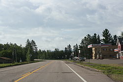
Looking south at Marengo on WIS13
|
|
| Coordinates: 46°25′21″N 90°49′01″W / 46.42250°N 90.81694°WCoordinates: 46°25′21″N 90°49′01″W / 46.42250°N 90.81694°W | |
| Country | United States |
| State | Wisconsin |
| County | Ashland |
| Town | White River |
| Area | |
| • Total | 1.024 sq mi (2.65 km2) |
| • Land | 1.024 sq mi (2.65 km2) |
| • Water | 0 sq mi (0 km2) |
| Elevation | 761 ft (232 m) |
| Population (2010) | |
| • Total | 111 |
| • Density | 110/sq mi (42/km2) |
| Time zone | Central (CST) (UTC-6) |
| • Summer (DST) | CDT (UTC-5) |
| ZIP code | 54855 |
| Area code(s) | 715 & 534 |
| GNIS feature ID | 1569024 |
Marengo is an unincorporated census-designated place located in the town of White River, Ashland County, Wisconsin, United States. Marengo is located on Wisconsin Highway 13 10 miles (16 km) northwest of Mellen. Marengo had a post office, which closed on June 27, 2009. At the 2010 census, its population was 111.
...
Wikipedia

