Marble Canyon
| Marble Canyon | |
|---|---|

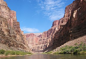
A section of Marble Canyon from river level
|
|
| Geography | |
| Coordinates | 36°51′49″N 111°35′25″W / 36.863622°N 111.590152°WCoordinates: 36°51′49″N 111°35′25″W / 36.863622°N 111.590152°W |
Marble Canyon is the section of the Colorado River canyon in northern Arizona from Lee's Ferry to the confluence with the Little Colorado River, which marks the beginning of the Grand Canyon.
Lee's Ferry is a common launching point for river runners starting their journey through the Grand Canyon. Marble Canyon is also well known for the Navajo Bridge, where US Highway 89A crosses the Colorado River.
Marble Canyon marks the western boundary of the Navajo Nation. In 1975, the former Marble Canyon National Monument, which followed the Colorado River northeast from the Grand Canyon to Lee's Ferry, was made part of Grand Canyon National Park.
The name Marble Canyon is a misnomer because there is no marble there. Although Powell knew this when he named the canyon, he thought the polished limestone looked like marble. In his words, "The limestone of the canyon is often polished, and makes a beautiful marble. Sometimes the rocks are of many colors - white, gray, pink, and purple, with saffron tints"
Marble Canyon is the site of one of the last great proposed dam projects on the Colorado, the Marble Canyon Dam. Proposed and investigated in the early 1950s by the United States Bureau of Reclamation, the proposal met substantial opposition, notably from the Sierra Club, when a revived proposal was considered by the state of Arizona as part of the Central Arizona Project from 1965 to 1968. The proposed dam was finally abandoned in 1968. Exploratory holes, which were drilled in the Redwall Limestone of the canyon walls in an early phase of the abortive project, can still be seen at Mile 39.2.
...
Wikipedia
