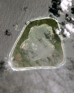
Manra
| Native name: Sydney Island | |
|---|---|
 |
|

Map of Manra Island
|
|
| Geography | |
| Archipelago | Phoenix Islands |
| Area | 4.4 km2 (1.7 sq mi) |
| Administration | |
|
Kiribati
|
|
| Demographics | |
| Population | 0 |
Coordinates: 4°27′S 171°16′W / 4.450°S 171.267°W
Manra Island or Sydney Island, is one of the Phoenix Islands in the Republic of Kiribati. It lies at 4°27′S 171°16′W / 4.450°S 171.267°W. longitude, and has an area of 4.4 km2. and an elevation of approximately six meters. Together with the seven other Phoenix Islands, it forms part of the Phoenix Islands Protected Area,.Charles Darwin visited the island during his five-year voyage (1831-1836), following which in 1842 he published an explanation for the creation of coral atolls in the South Pacific.
Though it has been occupied at various times in the past (including as late as 1963), Manra is currently uninhabited.
Manra is approximately triangular in shape, measuring approximately 3.2 km by 2.8 km. It completely surrounds a hyper-saline lagoon without outlet to the sea, containing depths of five to six meters. The island is covered with coconut palms, scrub forest, herbs and grasses, including the species Tournefortia, Pisonia, Morinda, Cordia, Guettarda, and Scaevola. Manra was formerly a functioning copra plantation, though it is no longer.
...
Wikipedia
